Title and statement of responsibility area
Titel
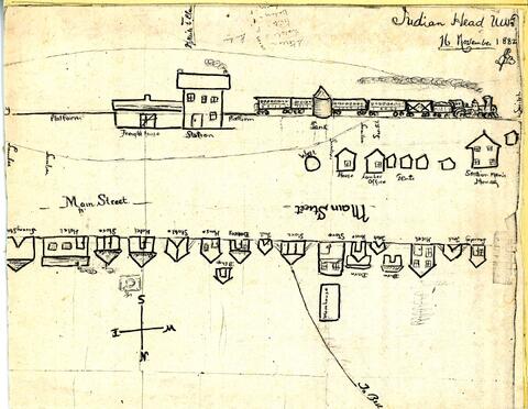
Hand-drawn map/sketch of Indian Head in 1882
Algemene aanduiding van het materiaal
- Graphic material
Parallelle titel
Overige titelinformatie
Title statements of responsibility
Titel aantekeningen
Beschrijvingsniveau
Stuk
archiefbewaarplaats
referentie code
Editie
Editie
Edition statement of responsibility
Class of material specific details area
Statement of scale (cartographic)
Statement of projection (cartographic)
Statement of coordinates (cartographic)
Statement of scale (architectural)
Issuing jurisdiction and denomination (philatelic)
Datering archiefvorming
Datum(s)
Fysieke beschrijving
Fysieke beschrijving
Hand-drawn sketch/map: b&w; 18 x 24 cm
Publisher's series area
Title proper of publisher's series
Parallel titles of publisher's series
Other title information of publisher's series
Statement of responsibility relating to publisher's series
Numbering within publisher's series
Note on publisher's series
Archivistische beschrijving
Naam van de archiefvormer
Biografie
Edwin Jackson Brooks was born in Lennoxville, Quebec, in 1949. He and his twin brother Edward arrived in July, 1882 and chose land just west of Indian Head, only to be told that the land had already been reserved by the Qu'Appelle Valley Company (Bell Farm). He later chose land north of Indian Head (Wide Awake District). He became a prominent citizen and merchant in Indian Head. In 1885, he was selected to serve on the jury for the trial of Louis Riel.
Geschiedenis beheer
Bereik en inhoud
Sketch/map by Edwin J. Brooks of the CPR station and buildings along the railway - all labelled. A path (later Grand Avenue) goes to the northwest and is labelled "To Bell..."
Aantekeningen
Materiële staat
Directe bron van verwerving
Ordening
Taal van het materiaal
Schrift van het materiaal
Plaats van originelen
PS2
Beschikbaarheid in andere opslagformaten
Restrictions on access
Termen voor gebruik, reproductie en publicatie.
Toegangen
Associated materials
Aanvullingen
Algemene aantekening
The sketch was before Indian Head was a town and so the only street, labelled Main Street, is actually North Railway Avenue - possibly the easterly part being present-day Main Street, which currently begins at the corner of Grand Avenue and North Railway Avenue and proceeds northeasterly..
Reverse: "Main Street 1882. Copy of sketch map drawn by E.J. Brooks for his wife on Nov. 16, '82. Vital Statistics: Stores = 3, Hotels = 3, Tents = 8, Bakery = 1,Laundry = 1, Houses = 4, Livery barn = 1. All strung along the newly laid track, opposite the old station and freight shed."
Alternative identifier(s)
Standard number area
Standaard nummer
Trefwoorden
Onderwerp trefwoord
Geografische trefwoorden
Naam ontsluitingsterm
- Brooks, Edwin Jackson (Onderwerp)