
- RO8.002
- Item
- [1930]
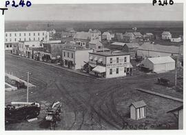
Rosetown Main Street viewed from the top of the CNR Station.
Rosetown Main Street viewed from the top of the CNR Station.

Aerial photo showing the corner of the Rosetown Co-op and part of the intersection at 3rd Avenue and Main, looking southwest. Macleods on the left. Elevator Row in the background.
Rosetown 100 block Main Street east side
100 block Main St. Rosetown, business and residential areas shown.

Probably taken from high on the Pioneer elevator. Shows Highway #7 facing east. Maine's windmill to pump water, baggage wagon on CN platform, white fence around stockyard and loading chute. Main CNR track and 2 sidings. East of town is flooded except for the highway.

CNR Station & Highway Businesses
Taken from the Pioneer elevator, this photo shows a CNR baggage wagon on the platform. Security Lumber (behind station) was open until 1970. In the background is the Flour Mill, Esso fuel tanks and storage building; the windmill is a pump for Maine's Water.

Highway 7 in the Early 20th Century
Hyslop Motors in the foreground; school visible in the background in front of the church.

Photo taken from tower of Anglican Church. Macleods, Clement's Funeral Home, Post Office, Rosetown Bakery (burned down), IGA (burned down). Pioneer elevator in background.