
- RO8.002
- Item
- [1930]
Rosetown Main Street viewed from the top of the CNR Station.
457 results with digital objects Show results with digital objects
Rosetown Main Street viewed from the top of the CNR Station.

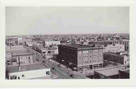
Aerial photo showing the corner of the Rosetown Co-op and part of the intersection at 3rd Avenue and Main, looking southwest. Macleods on the left. Elevator Row in the background.
Part of City of Regina fonds
Looking west down 11th Avenue from the corner of 11th Avenue and Cornwall Street

Photo taken from the Pioneer elevator. Skating rink and Community Hall to the right. C.N. Freight Office and Shed in foreground.

A bird's eye view of Rosetown looking north, taken from the Anglican Church. Thought to be the creamery in the background on the right.
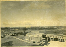
Aerial view looking northwest of Law Building; Robin Hood Mills elevator in background.
Bio/Historical Note: The Law and Commerce Buildings were designed and constructed as part of a single project between 1965 and 1967. The architect was John Holliday-Scott of the Saskatoon firm Holliday-Scott & Associates.
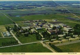
Lakeland College, Vermilion, Alberta
Part of LRA Photograph Collection
Aerial view of Lakeland College campus in Vermilion, Alberta.
Indian Head Forest Nursery Station.
Part of Agriculture Collection
Aerial view of the Indian Head Forest Nursery Station in 1952.
Experimental Farm Regina Substation
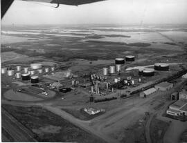
Husky Oil refinery in Lloydminster, Sask.
Aerial view of Husky Oil refinery in Lloydminster, Saskatchewan.
Ritchie Studios

Hospital, Nurses Residence, & Convent
L-R: Tennis court, nurses residence, hospital, and St. Theresa's Convent.

Taken from the air looking south along Highway 4 to junction at Highway 7. Hi-way Refinery top right. Saskatchewan Wheat Pool top. White Rose Bulk Plant to the east. South on Main Street to Railroad Avenue.

Highway 7 in the Early 20th Century
Hyslop Motors in the foreground; school visible in the background in front of the church.
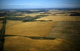
Part of LRA Photograph Collection
Aerial view of highway 17 and wheat fields.
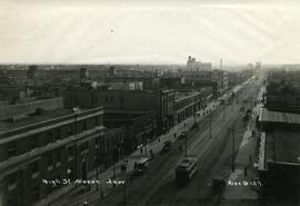
High Street in Moose Jaw looking West
Part of Rice's Studio collection
Aerial view of High Street in Moose Jaw, SK looking west; a streetcar is travelling down the street, pedestrians are on the sidewalks and cars are parked along the street.
Rice, Lewis

Aerial view of Rosetown facing southeast. Front says "Rosetown, Saskatchewan. 'Heart of the Wheat Belt.'"