Aligned coal pebbles and streaks in till - Eastend, Sask
Aligned coal pebbles and streaks in till - Eastend, Sask
Sangamon gravel and underlying till
Sangamon gravel and underlying till
Steeply dipping sands and gravels - Pipestone Creek, Sask
Steeply dipping sands and gravels - Pipestone Creek, Sask
Fluvial sand and gravel overlying till - south of Eastend, Sask
Fluvial sand and gravel overlying till - south of Eastend, Sask
Sand filled ice-wedge in till near Wolf Point, Montana
Sand filled ice-wedge in till near Wolf Point, Montana
Washboard moraine
Washboard moraine
Length of view of linear till ridge
Length of view of linear till ridge
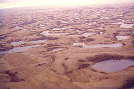
Aerial view of dead ice moraine with knob and kettle topography
Aerial view of dead ice moraine - near Lampman, Sask
Aerial view of dead ice moraine - near Lampman, Sask
Kame near Benson, Sask
Kame near Benson, Sask
Kames. Lost Horse Hills west of Handsworth, Sask
Kames. Lost Horse Hills west of Handsworth, Sask
Ice-contact gravel ridge - northeast of Lampman, Saskatchewan
Index map of southwestern Saskatchewan
Index map of southwestern Saskatchewan
Drumlinized kame - Wright's gravel pit
Drumlinized kame - Wright's gravel pit
Experimental formation of drumlin
Experimental formation of drumlin