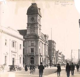
11th Avenue and Scarth Street in Regina
- CORA-RPL-B-204
- Item
- ca. 1911
Part of City of Regina fonds
Corner of 11th Avenue and Scarth Street with the Post Office building on the left and the Imperial Bank of Canada building in left foreground.

458 results with digital objects Show results with digital objects
11th Avenue and Scarth Street in Regina
Part of City of Regina fonds
Corner of 11th Avenue and Scarth Street with the Post Office building on the left and the Imperial Bank of Canada building in left foreground.
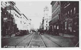
11th Avenue looking east, Regina, Saskatchewan
Part of City of Regina fonds
2100 block of 11th Avenue facing east. Old Post Office building is in background.
Part of City of Regina fonds
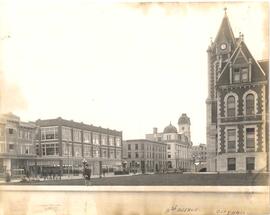
View of 11th Avenue from Rose Street. Regina City Hall is seen on the right with the G.S. Wood Building on the left, R.H. Williams Department Store in middle along with the Leader Building.
150 Stories Oral History Project Collection
This collection consists of electronic audio and video recordings collected for the 150 Stories Oral History Project. The project involved interviewing members of Regina's Indigenous community.
City of Regina Archives
Part of City of Regina fonds
1700 block Scarth Street looking south from South Railway. The Jones Shoe Company is in left foreground on east side of the street. In right foreground is the Mickleborough Block.
Part of City of Regina fonds
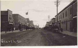
1800 block Scarth Street looking south from 11th Avenue.

Part of City of Regina fonds
1800 block Scarth Street looking south from 11th Avenue along the west side of Scarth Street.
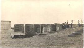
48 inch water-pipe for Boggy Creek
Part of City of Regina fonds
48 inch water pipe for the Boggy Creek waterworks project. View is along 7th Avenue.
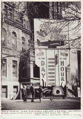
6th Victory Loan Progress Indicator Board
Part of City of Regina fonds
The 6th Victory Loan Progress Indicator Board at City Hall square, 11th Avenue and Hamilton Street. Norman Ruse, Publicity Committee, is at left, with a uniformed man and woman.
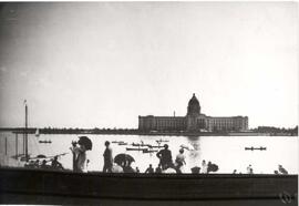
A day out at Wascana Park in Regina
Part of City of Regina fonds
People enjoying a boat race on Wascana Lake with the newly constructed Legislative Buildings in background.
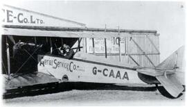
Part of City of Regina fonds
Plane and hangar at Aerial Service Co. Ltd., Canada's first licensed aerodrome.
Part of City of Regina fonds
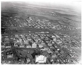
Aerial view of downtown Regina (looking north); Hotel Saskatchewan (Victoria Avenue) to northern City Limits; Metropolitan United Church (Lorne Street) to Broad Street.
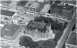
Aerial view of Regina City Hall and Downtown
Part of City of Regina fonds
Aerial view of downtown Regina with Regina City Hall [nicknamed the "Gingerbread Hall"]in centre foreground.
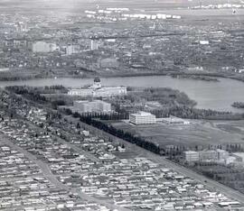
Aerial view of Regina looking northeast
Part of City of Regina fonds
Aerial view looking northeast over the city. The Legislative Buildings, Wascana Lake and Campion College are seen in foreground. From Thornton Avenue to outer city limits (north), Rae Street to east edge of Wascana Park.
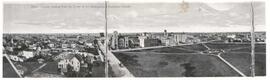
Aerial view of Regina, Saskatchewan
Part of City of Regina fonds
The City of Regina as seen from the top of the Metropolitan Methodist Church. Victoria Park is visible in the left of the frame. Little landscaping has been done to the park.