- A-6411
- Stuk
- [ca. 1980]
Images taken south of College Drive looking across campus.
458 results with digital objects Show results with digital objects
Images taken south of College Drive looking across campus.
View looking northeast with Griffiths Stadium and ballfields along bottom of image. College Drive runs through centre; campus buildings visible in background.
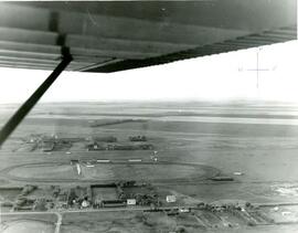
Aerial photo of Indian Head horse race track and former airport
Part of Town Collection
Photograph taken from an airplane looking north over the fairgrounds/horse race track to the former airport - now Indian Head Golf Course.
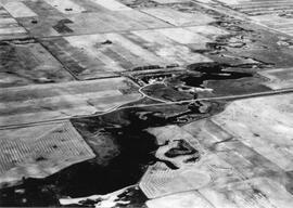
An aerial view of the Blind Creek near Zealandia flooding in the spring. The water flowed west to east and met up with the South Saskatchewan River near Saskatoon.

Rosetown in 1911, facing north. Barns in forefront, houses behind. Long building is Colwell Lumber, Pioneer stables across the street. Douglas Bros. to the left of Colwell. Buildings on the right are on the west side of Main Street. Photo taken by B.P. Skewis.

CNR Station & Highway Businesses
Taken from the Pioneer elevator, this photo shows a CNR baggage wagon on the platform. Security Lumber (behind station) was open until 1970. In the background is the Flour Mill, Esso fuel tanks and storage building; the windmill is a pump for Maine's Water.

Two-storey house in foreground was the first hospital in Rosetown, Dr. Myers' residence, located at 114 3rd Avenue East. Square house next to it is possibly the McCulloch residence. Believed to be the United Church in the background on the right. Photo taken from the Anglican Church tower.

Taken from the Searle elevator looking northeast. L-R: old rink, Stewart School, Smith School, Roman Cathoilc Church, Anglican Church; elevators at North Rosetown in background.

Hospital to the left, Convent to the right. Facing west-northwest.
Zonder titel

Facing south. Elevators visible along the highway at the south end of town. Main Street is situated between the 2 elevators on an angle. Anglican Church with steeple at centre of picture. United Church in background at left. Old coal dock can be seen at the left just at the horizon. No telephone wires yet.

Showing from lower left to upper right: 1st Avenue West, Main Street; perpendicular right to left: railroad track and Highway 7. Shows Rosetown Hotel with 3 storeys.

Aerial view of all of Rosetown. South end of town at bottom of photo (elevators visible).

Aerial view of Rosetown during road building days. Main Street on the left side, 1st Avenue East on the right side. Facing north.

Shows the layout of Rosetown from Highway 4 N to 6th Ave. and Main Street to 9th Ave.

Rosetown facing northeast. Appears to be late fall.