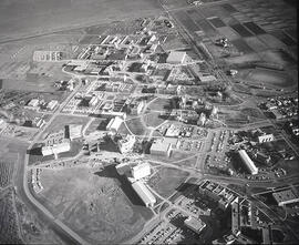
View looking west with campus buildings dominating photograph. College Drive runs along left side of image; river and west side residential areas in background.
View looking northeast with Griffiths Stadium and ballfields along bottom of image. College Drive runs through centre; campus buildings visible in background.
View looking southeast with campus and east side residential areas at centre of image. University lands at bottom; river and west side residential areas in background.
View looking west with Rutherford Rink at centre of image; campus buildings in foreground. College Drive runs along left of photograph. 25th Street Bridge, river and west side in background.
Progress shot of construction of the Linear Accelerator Building. View facing south with construction in foreground; the Bowl and surrounding buildings in background.
View looking northeast of campus, with President's Residence in foreground. Arts Tower at centre of image, with surrounding buildings. College Drive runs along right side of image, to the prairie in background.
View looking northwest of campus, with University (Main) Barn and Physical Education Building in foreground. The Bowl and Arts Tower visible in background, with surrounding buildings. College Drive runs along the left of image; river and west side of city visible in background.
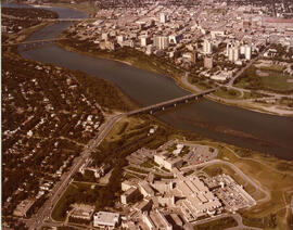
View looking north with Griffiths Stadium in foreground; South Saskatchewan River and northern residential areas in background. College Drive runs along bottom of image.
View looking west at Physical Education Building, Engineering Building, and University (Main( Barn near centre of image. Protein, Oil and Starch (POS) Pilot Plant, Varsity View residential areas and College Drive runs at lleft, South Saskatchewan River and west side residential areas visible in background.
View facing southwest with campus buildings at right foreground; Varsity View homes at left foreground. Downtown Saskatoon and South Saskatchewan River in background.