
- RO1.014
- Pièce
- pre-1949
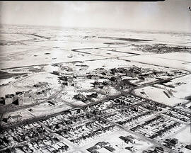
Fait partie de Rosetown General Photograph Collection
Looking northeast from south of town. Herschel Arthur farm at right in centre. CNR rail line marked.
Fait partie de Rosetown General Photograph Collection
Looking northeast from south of town. Herschel Arthur farm at right in centre. CNR rail line marked.

Fait partie de Rosetown General Photograph Collection
A view from the south of Rosetown. The Catholic school, hospital, nurses residence, old rink, fairgrounds, and Main Street can be seen.

Fait partie de Rosetown General Photograph Collection
Rosetown Main Street viewed from the top of the CNR Station.

Fait partie de Rosetown General Photograph Collection
Main Street Rosetown, taken from the top of the elevator. Included is the postcard the photo was reproduced from, with a handwritten note dated July 12, 1912.

Fait partie de Rosetown General Photograph Collection
Aerial photo showing the corner of the Rosetown Co-op and part of the intersection at 3rd Avenue and Main, looking southwest. Macleods on the left. Elevator Row in the background.

Fait partie de Rosetown General Photograph Collection
The Rosetown Co-op Shopping Centre under construction, likely just before the fire that consumed it. The Rosetown Elks Hall, Credit Union, and Presbyterian Church to the right. Rosetown water tower visible in background on right; St. Joseph's Convent on left.
Fait partie de University of Saskatchewan Photograph Collection
Winter view looking north across campus with Varsity View neighbourhood in foreground and Sutherland in background.
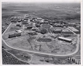
Fait partie de University of Saskatchewan Photograph Collection
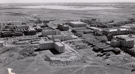
View of construction work on Biology and Arts buildings. Chemistry Building, Administration Building, north wing of Murray Memorial (Main) Library, and the Bowl in background.

Fait partie de University of Saskatchewan Photograph Collection
Looking north with University residential areas in foreground, with Sheptytsky Institute (1236 College Drive) and intersection of Wiggins Avenue North and College Drive at centre. Campus buildings, river and west side residential areas visible in background. [Taken from Luther Tower].
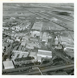
Fait partie de University of Saskatchewan Photograph Collection
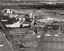
View looking northeast with College Drive running along bottom of image. Physical Education building, Hangar Building, and greenhouses in foreground, with surrounding campus buildings and fields in background.
Fait partie de University of Saskatchewan Photograph Collection
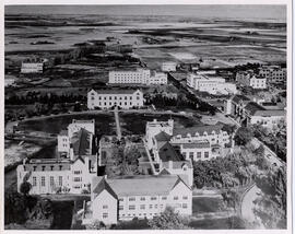
View facing southeast with Arts Building and University Hospital in foreground; Chemistry Building, the Bowl and Administration Building at centre.
Fait partie de University of Saskatchewan Photograph Collection
Looking west at University (Main) Barn at centre; Chemistry Building, Administration Building, and other campus buildings also visible. College Drive runs at bottom left.
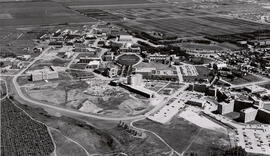
Fait partie de University of Saskatchewan Photograph Collection
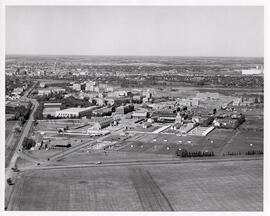
Looking west at construction work on Biology, Arts, and Animal Science buildings. Other campus buildings north of College Drive are visible; Preston Avenue runs along bottom of image.
Fait partie de University of Saskatchewan Photograph Collection
Looking north at Memorial Union Building in middle foreground. Buildings visible around the Bowl are (r to l): Administration Building, Saskatchewan Hall and Qu'Appelle Hall. Construction of north wing of Murray Memorial (Main) Library at left. Physics and Engineering buildings vislble.
Fait partie de University of Saskatchewan Photograph Collection
Aerial view facing east of the Administration, Engineering, Physics, and Chemistry buildings and other buildings. Stock barns and fields in background.