Aerial view of Museum and grounds
- MUSE2.002
- Stuk
- 2008
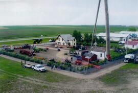
Aerial view shows the Tea House, Fire Hall, School, Church, Blacksmith Shop, tractors, and main buildings. Photographed from a SaskTel balloon in 2008.
Aerial view of Museum and grounds
Aerial view shows the Tea House, Fire Hall, School, Church, Blacksmith Shop, tractors, and main buildings. Photographed from a SaskTel balloon in 2008.

An aerial view of Rosetown looking northwest.

An aerial view of Rosetown looking north. Appears to be late fall.

Aerial view of Rosetown during road building days. Main Street on the left side, 1st Avenue East on the right side. Facing north.

Looking northeast. Main Street, Highway 4, and 6th Avenue are marked.

Shows the layout of Rosetown from Highway 4 N to 6th Ave. and Main Street to 9th Ave.

Looking east along CN railroad. Herschel Arthur farm to the right, 2nd Avenue East. Imperial Oil Bulk. Flooding east of Rosetown. John Bone farm top left.

Taken from the air looking south along Highway 4 to junction at Highway 7. Hi-way Refinery top right. Saskatchewan Wheat Pool top. White Rose Bulk Plant to the east. South on Main Street to Railroad Avenue.

West end of town, pre-1949. Top: CNR and Highway 7. Right: Highway 4. Extends from 8th Avenue at the bottom to 1st Avenue West on the left.

Taken from the air looking north along Highway 4. Saskatchewan Wheat Pool elevator at lower left. Skating rink and Catholic church on left.

Rosetown from the air.

Rosetown in 1953 or 1954 looking southeast. Underside of plane wing in upper corner of photo.

Hospital, Nurses Residence, & Convent
L-R: Tennis court, nurses residence, hospital, and St. Theresa's Convent.

Rosetown from the air looking southwest. Centre: Anglican Church. Across Main St.: Dr. Perrim's House. South: Presbyterian Church, Rosetown Hotel.

Looking northeast from south of town. Herschel Arthur farm at right in centre. CNR rail line marked.