
Highway 7 in the Early 20th Century
- RO7.006
- Item
- [1930-1949]
Hyslop Motors in the foreground; school visible in the background in front of the church.

Highway 7 in the Early 20th Century
Hyslop Motors in the foreground; school visible in the background in front of the church.
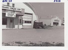
Howard Concave and Sno-Pro Sports
Howard Concave Corp. building and Sno-Pro building with the Motor Inn sign in the background.
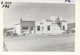
Prairie Farm Equipment, J.I. Case dealership with a tractor parked beside the building.
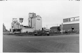
Kentucky Fried Chicken with Greenfield Agro, Pool elevators A & B and the Pioneer elevators viewed in the background as seen from the corners of Hwys 4 & 7 looking south east.

Legion on parade, heading north across the intersection between the 2nd and 3rd blocks of Main Street. In background L-R: Berschied Drugs and Flower Shop, Post Office (across intersection), Bill Ogenchuk Jewellery sign, Jack Cracknell's Store sign, Dry Cleaners. Truck in foreground: McCulloch Bros.
Leith & Glassford Agency and Gilchrist Accounting
The east side of the 400 block of Main Street as follows: Leith & Glassford Agency dealing in real estate, insurance and investments. Gilchrist & Co. Accountants. Masonic Hall, small house and Anglican Church.

Brick Liquor Board Store located at 123 1st Avenue East from 1959 to 1982, when it moved to its present location off Highway 7.
Rose Studio
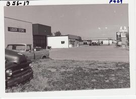
Liquor Store, Lloyd's Korner Store & Shell
Two older trucks are in the left side of the picture with the businesses left to right: Liquor Store, Lloyd's Korner Store, Shell Service Station.
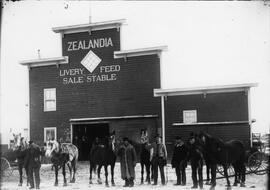
Five men stand outside Thomas Sulland's Livery Feed and Sale Stable with six horses in winter. Three more men stand inside the stable. Located on the south side of 1st Avenue.

300 block looking south. On left: Norm Smith's O.K. Economy, (possibly) Mrs. Askett's Candy Store, unknown, vacant lot (previously where the Rex Theatre stood until the fire in 1919). On right side: Presbyterian (formerly Methodist) Church, Quality Meat Market, R.M. of St. Andrews municipal office.
Randall Photo Shop (Biggar)

Looking south down Main Street from the 300 block. Sewing machine agency on right hand side with two men standing out front. Photo by Ward Photo Studios.

The west side of the 100 block Main Street as viewed from across Highway #7 as follows: Louis' Dining Room and Lounge, Saan Store and Nichols Mobility.

Aerial photo showing the corner of the Rosetown Co-op and part of the intersection at 3rd Avenue and Main, looking southwest. Macleods on the left. Elevator Row in the background.

Five buildings on Main Street, west side. The Pioneer Boarding House is on the left.
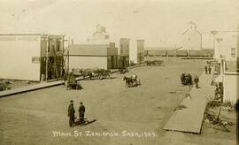
West side of Main Street in Zealandia looking north. A number of people walking about and a hardware and furniture store under construction with six horses and wagons on the street. A Canadian Northern train can be seen in the background.