- A-197
- Item
- 1955
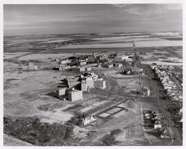
Looking east along College Street of construction of the Canada Agriculture Research Building. University Hospital and President's Residence in foreground.

20973 results with digital objects Show results with digital objects
Looking east along College Street of construction of the Canada Agriculture Research Building. University Hospital and President's Residence in foreground.
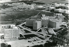
Looking east at University Hospital and Ellis Hall in foreground, Chemistry Building; north wing of Murray Memorial (Main) Library in background.
Looking west at College Drive, partial view of Griffiths Stadium, Varsity View homes in foreground. Campus buildings and Saskatoon in background.
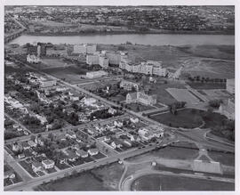
View of campus looking northeast; west side residential area, 25th Street Bridge and river in foreground. Campus building at centre of image, with College Drive visible at right.
View looking northwest, with partial view of Griffiths Stadium and tennis courts in foreground. The Bowl is at centre of image; river, city, and prairie fields in background.
View looking northeast with College Drive running along bottom of image. National Research Council building at centre with surrounding buildings; prairie and Preston Avenue in background.
View looking northwest with College Drive running along bottom of image. The Bowl is at centre, with surrounding buildings; river and city in background.
Aerial view looking southwest with Crop Science Field Laboratory and University land in foreground. Campus buildings at centre of photograph; river and city in background.
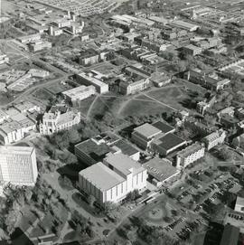
Aerial view looking northeast with Arts Tower, Murray Building, and Place Riel in foreground. The Bowl and surrounding buildings at centre of photograph;
Aerial view looking west with University land and agricultural buildings in foreground. Campus buildings at centre of photograph; river and city in background.
View of campus looking northeast. Arts Tower at centre of photograph with surrounding buildings. University lands and Sutherland in background.
View of campus looking southwest. Western College of Veterinary Medicine at centre of image with surrounding buildings. College Drive and Griffiths Stadium runs along top of image.
View of campus looking northeast with 25th Street Bridge and river in foreground. Campus buildings at centre, with College Drive running along right side of image.
View looking southwest with whole of main campus visible. University lands along the bottom of image; river, 25th Street Bridge, and east side residential areas visible in background.
View looking west of campus at centre of photograph; Preston Avenue and University lands at bottom. College Drive runs along left side; river and west side residential areas visible in background.