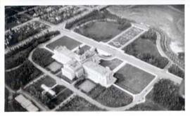
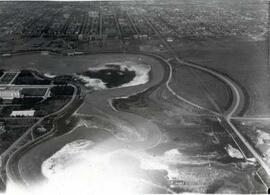
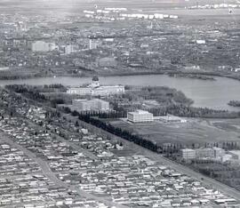
Saskatchewan Legislative Grounds and Wascana Lake
- CORA-A-535
- Item
- September, 1931
Parte de City of Regina fonds
Aerial view of the Saskatchewan Legislative Grounds and Wascana Lake; note that Wascana Lake is drained/empty.
Sem título
Saskatchewan Legislative Grounds and Wascana Lake
Parte de City of Regina fonds
Aerial view of the Saskatchewan Legislative Grounds and Wascana Lake; note that Wascana Lake is drained/empty.
Sem título
Parte de City of Regina fonds
Looking west down 11th Avenue from the corner of 11th Avenue and Cornwall Street
Parte de City of Regina fonds
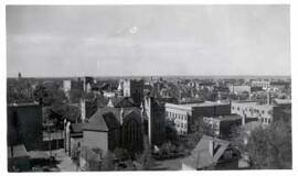
Birds' Eye View of Regina. The view of the south western downtown area is taken from the top of the Canada Life Building. The Knox Metropolitan Church is visible.
Parte de City of Regina fonds
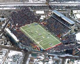
Bird's eye view of Taylor Field at halftime show of 1995 Grey Cup game
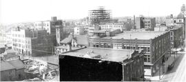
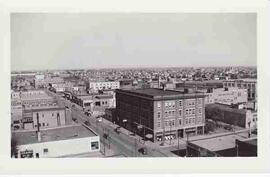
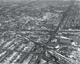
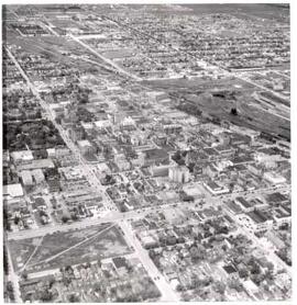
Birds-Eye View of Downtown Regina
Parte de City of Regina fonds
Birds-eye view of downtown Regina, looking east down 11th Avenue. McCallum Hill Building is under construction. Old Post Office is visible in far right of frame.
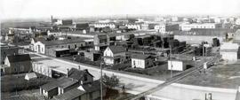
Old Warehouse District in Regina
Parte de City of Regina fonds
Aerial view of old warehouse district from the corner of Scarth Street and Dewdney Avenue in Regina, Saskatchewan
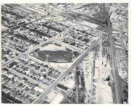
Parte de City of Regina fonds
Aerial photograph of Taylor Field (home of the Saskatchewan Roughriders) and surrounding neighbourhood.
Parte de City of Regina fonds
An empty Wascana Lake before the 1931 deepening.
Parte de City of Regina fonds
A drained and empty Wascana Lake before it was dredged and deepened in the fall of 1931. As part of a government relief project, 2,100 men (only men who were married and had children were allowed to work on the project) widened and dredged the lake bed and created two islands (Willow and Spruce Island) using only hand tools and horse-drawn wagons.
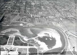
Aerial view of Regina looking northeast
Parte de City of Regina fonds
Aerial view looking northeast over the city. The Legislative Buildings, Wascana Lake and Campion College are seen in foreground. From Thornton Avenue to outer city limits (north), Rae Street to east edge of Wascana Park.
Aerial view of the CP rail-yards and warehouse districts
Parte de City of Regina fonds
Rail-yards and warehouse district from the air. From Broad Street to Broder Street, Arcola Avenue to outer city limits (north).
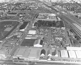
Exhibition Grounds with midway
Parte de City of Regina fonds
Aerial view of Exhibition Grounds looking east from Regina Avenue. Midway and buildings in foreground, racetrack to the left.
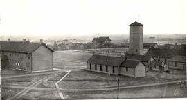
Birds'-Eye view of the North-West Mounted Police (NWMP) yard
Parte de City of Regina fonds
Birds'-Eye view of the North-West Mounted Police (NWMP) yard and buildings
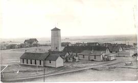
North West Mounted Police (NWMP) Barracks
Parte de City of Regina fonds
North West Mounted Police barracks, birds'-eye view
Parte de City of Regina fonds
Regina's downtown from the air. Victoria Park to left middle, gingerbread City Hall to middle, roundhouse to right middle. The area from 12th Avenue to South Railway Street, Pasqua Street to Halifax Street is seen.