- A-10277
- Stuk
- Summer 1967
View of campus looking northeast. Arts Tower at centre of photograph with surrounding buildings. University lands and Sutherland in background.
73 results with digital objects Show results with digital objects
View of campus looking northeast. Arts Tower at centre of photograph with surrounding buildings. University lands and Sutherland in background.
View of campus looking southwest. Western College of Veterinary Medicine at centre of image with surrounding buildings. College Drive and Griffiths Stadium runs along top of image.
View of campus looking north. Griffiths Stadium and fields in foreground; College Drive runs through centre of photograph. Campus buildings in background.
View of campus looking northeast with 25th Street Bridge and river in foreground. Campus buildings at centre, with College Drive running along right side of image.
View looking west with campus buildings dominating photograph. College Drive runs along left side of image; river and west side residential areas in background.
View looking southwest with whole of main campus visible. University lands along the bottom of image; river, 25th Street Bridge, and east side residential areas visible in background.
View looking northeast with Griffiths Stadium and ballfields along bottom of image. College Drive runs through centre; campus buildings visible in background.
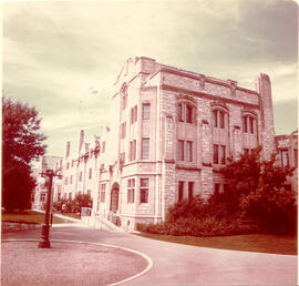
Summer scene looking south of Qu'Appelle Hall, the men's residence. Sidewalk and lamp post in foreground.
View looking west of campus at centre of photograph; Preston Avenue and University lands at bottom. College Drive runs along left side; river and west side residential areas visible in background.
View looking southwest with campus at centre of image. Preston Avenue and University lands at bottom of photograph, with east side residential areas visible. River and west side residential areas in background.

View looking southeast with campus at centre of image. River, riverbank and Lutheran Seminary at bottom of photograph; College Drive intersects image. University lands and residential areas in background.
View looking southeast with campus and east side residential areas at centre of image. University lands at bottom; river and west side residential areas in background.
View looking northeast with campus buildings at centre of image. Spadina Crescent East, 25th Street Bridge, and South Saskatchewan River in foreground.
View looking southwest with University lands and campus buildings in foreground. East side residential areas, 25th Street Bridge, river and west side in background.
View looking west with the Bowl at centre of image; surrounding campus buildings in foreground. College Drive runs along left side of photograph; 25th Street Bridge, river and west side in background.