View looking west of campus at centre of photograph; Preston Avenue and University lands at bottom. College Drive runs along left side; river and west side residential areas visible in background.
View looking southwest with campus at centre of image. Preston Avenue and University lands at bottom of photograph, with east side residential areas visible. River and west side residential areas in background.
View looking southeast with campus at centre of image. River, riverbank and Lutheran Seminary at bottom of photograph; College Drive intersects image. University lands and residential areas in background.
View looking southeast with campus and east side residential areas at centre of image. University lands at bottom; river and west side residential areas in background.
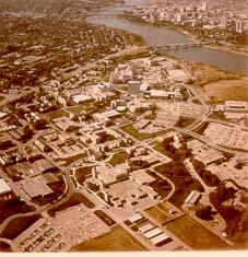
View looking northeast with campus buildings at centre of image. Spadina Crescent East, 25th Street Bridge, and South Saskatchewan River in foreground.
View looking southwest with University lands and campus buildings in foreground. East side residential areas, 25th Street Bridge, river and west side in background.
View looking west with the Bowl at centre of image; surrounding campus buildings in foreground. College Drive runs along left side of photograph; 25th Street Bridge, river and west side in background.
View looking west with the Bowl and Arts Tower near centre of image. campus buildings in foreground. 25th Street Bridge, river and west side in background.
View looking west with Rutherford Rink at centre of image; campus buildings in foreground. College Drive runs along left of photograph. 25th Street Bridge, river and west side in background.
View looking southwest with Arts Tower at centre of image; campus buildings in foreground. College Drive runs along left of photograph. East side residential areas, 25th Street Bridge, river and downtown area in background.