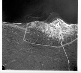
Aerial photo of Black Lake, Sask.
- MG 240 Box 5 II. Stony Rapids Project. Black Lake Aerial Photos. - 1971.
- Item
- 1971.
Parte deR.M. Bone fonds
At bottom of image: "NW 1181071-1-2".
Bio/historical note:
50 resultados con objetos digitales Muestra los resultados con objetos digitales
Aerial photo of Black Lake, Sask.
Parte deR.M. Bone fonds
At bottom of image: "NW 1181071-1-2".
Bio/historical note:
Flight plan of La Ronge, Sask.
Parte deR.M. Bone fonds
Map of flight plan for aerial photos of La Ronge; shows physical features; "C3-La Ronge and Air Ronge 1:5000 G 60521 20-5-76".
Lots and Blocks in Air Ronge, Sask.
Parte deR.M. Bone fonds
Part I - description of lot and block breakdown showing residents of Air Ronge. Part II - map indicating growth of Air Ronge.
Parte deR.M. Bone fonds
Part I - description of lot and block breakdown showing residents of Air Ronge. Part II - map indicating growth of Air Ronge, Sask.
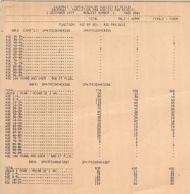
Air Ronge Population by Age and Sex. - Table
Parte deR.M. Bone fonds
Table includes numerous age groups by gender.
Bio/historical note:
Air Ronge Community Planners View.
Parte deR.M. Bone fonds
Report [written by R.M. Bone] describes existing layout and future development of Air Ronge, Sask.
Parte deR.M. Bone fonds
Report [written by R.M. Bone] discusses three different types of communities - resiential, institutional and commercial.
Housing and the Community. - Report.
Parte deR.M. Bone fonds
Report [written by R.M. Bone] describes philosophy of residential housing in communities.
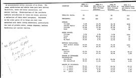
Table of statistics of housing in La Ronge, Sask. and area.
Parte deR.M. Bone fonds
Statistics include dwelling units, number of residents, sewage and water source. Source: "Statistics from EPEC Report on La Ronge".
Bio/historical note:
Parte deR.M. Bone fonds
Answers to problem areas with Air Ronge data, including unexplained abbreviations, and trailer courts and special leases not located on plan.
Bio/historical note:
This fonds consists primarily of material from two studies in which Dr. Bone was associated. The earliest, the "Stony Rapids Project", was conducted while Bone was in the Department of Geography. It started with a small grant from the Canadian Wildlife Service to examine the caribou hunt; ie. the number of people involved and the number of animals taken. The project, however, grew to encompass a wider study of the region and its inhabitants. The second study was undertaken while Bone was with the Institute of Northern Studies (INS). The Northern Saskatchewan Housing Needs Survey was a co-operative effort between the Department of Northern Saskatchewan and the Northern Municipal Council. The primary focus was to investigate the housing needs of the Métis in northern Saskatchewan. The INS was subcontracted to oversee the project, train the surveyors, enter the data, and write the final report. The resulting survey was more than an examination of housing needs. It also contains a great deal of socio-economic data which resulted in one of the most exhaustive studies of its kind. The fact that the surveyors came from the communities studied explains much of the data collection success. Both of these projects offer a unique snapshot of the communities studied. There is also material of a more general nature that deals with northern Saskatchewan, Alberta, Manitoba, and the Yukon and Northwest Territories.
Sin título
Parte deR.M. Bone fonds
Parte deR.M. Bone fonds
Northern Saskatchewan Housing Needs Survey.
Parte deR.M. Bone fonds
This series is arranged in alphabetical order by the settlement studied. There are two sets of lists: A. General files (boxes 1-5) and; B. Housing Needs Surveys (boxes 6-25).
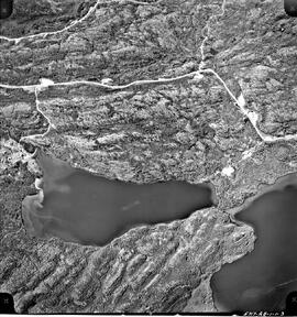
Aerial photo of Uranium City, Sask.
Parte deR.M. Bone fonds
Series of 43 mosaic photos. At bottom of image: "5717-AB-1-1-3" On back of image: "Job P 1613/59 / Roll 5717 / Flight Altitude - 7000 feet AMSL / Focal Length - 152.53 mm / Date of Photography - June 6 1960 / Time (GMT) 1220-1225 HRS / Photography by Hunting Survey Corporation Limited Toronto, Canada / Copyright - The Province of Saskatchewan Department of Highways"