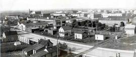
- CORA-RPL-B-331
- Item
- 1930
Parte de City of Regina fonds
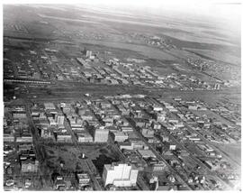
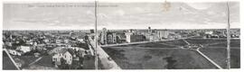
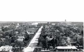
Aerial view of downtown Regina (looking north); Hotel Saskatchewan (Victoria Avenue) to northern City Limits; Metropolitan United Church (Lorne Street) to Broad Street.
Parte de City of Regina fonds
Aerial view of downtown Regina (looking north); Hotel Saskatchewan (Victoria Avenue) to northern City Limits; Metropolitan United Church (Lorne Street) to Broad Street.
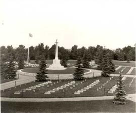
War Memorial, Soldiers' Plot, Regina Cemetery
Parte de City of Regina fonds
Aerial view of the War Memorial, Soldiers' Plot at the Regina Cemetery; architectural firm of Portnall and Clemnsha of Regina designed the war memorial.
Sem título
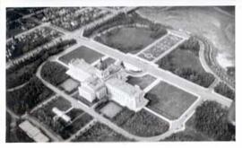
Saskatchewan Legislative Grounds and Wascana Lake
Parte de City of Regina fonds
Aerial view of the Saskatchewan Legislative Grounds and Wascana Lake; note that Wascana Lake is drained/empty.
Sem título
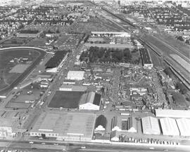
Exhibition Grounds with midway
Parte de City of Regina fonds
Aerial view of Exhibition Grounds looking east from Regina Avenue. Midway and buildings in foreground, racetrack to the left.
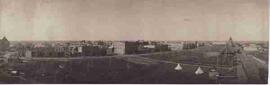
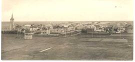
Aerial view of Regina, Saskatchewan
Parte de City of Regina fonds
The City of Regina as seen from the top of the Metropolitan Methodist Church. Victoria Park is visible in the left of the frame. Little landscaping has been done to the park.
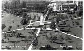
Birds'-eye view of Victoria Park in Regina
Parte de City of Regina fonds
Aerial view of Victoria Park in Regina, looking south towards Victoria Avenue. The Baptist Church and the Land Titles Building are visible and the Victoria Park Fountain is still the centre of Victoria Park (replaced by the World War I Cenotaph in 1928]
Parte de City of Regina fonds
Looking west down 11th Avenue from the corner of 11th Avenue and Cornwall Street
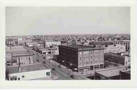
Birds-Eye View of Downtown Regina
Parte de City of Regina fonds
Birds-eye view of downtown Regina, looking east down 11th Avenue. McCallum Hill Building is under construction. Old Post Office is visible in far right of frame.
Scarth Street looking south from Hotel Saskatchewan
Parte de City of Regina fonds
Looking south on Scarth Street as seen from the Hotel Saskatchewan. Legislative Buildings are visible in background.
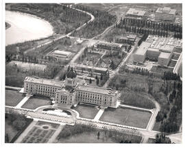
Saskatchewan Legislative Building and Grounds
Aerial view of the Saskatchewan Legislative Building and Grounds, including part of Wascana Lake and part of downtown Regina.
Sem título
Bird's eye view of Stanley Park & South Railway
Parte de City of Regina fonds
Bird's eye view of Stanley Park and South Railway Street. Looking southwest from the CPR station.
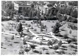
Victoria Park with Cenotaph, Regina
Parte de City of Regina fonds
Aerial/birds' eye view of Victoria Park and Cenotaph facing towards 12th Avenue and Cornwall Street.
Parte de City of Regina fonds
Aerial/bird's-eye view of Victoria Park looking southeast; band shell & cricket pitch in foreground.
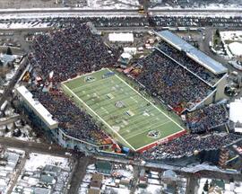
Parte de City of Regina fonds
Bird's eye view of Taylor Field at halftime show of 1995 Grey Cup game
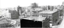
Old Warehouse District in Regina
Parte de City of Regina fonds
Aerial view of old warehouse district from the corner of Scarth Street and Dewdney Avenue in Regina, Saskatchewan