
Aerial photo of Uranium City, Saskatchewan
- A. General files. Uranium City. Air photos, Uranium City and El Dorado - 1959-1960.
- Stuk
- June 6, 1960
Part of R.M. Bone fonds
Aerial view of Uranium City, Saskatchewan.
Zonder titel
50 results with digital objects Show results with digital objects
Aerial photo of Uranium City, Saskatchewan
Part of R.M. Bone fonds
Aerial view of Uranium City, Saskatchewan.
Zonder titel
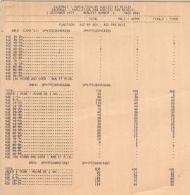
Air Ronge Population by Age and Sex. - Table
Part of R.M. Bone fonds
Table includes numerous age groups by gender.
Bio/historical note:
Part of R.M. Bone fonds
Answers to problem areas with Air Ronge data, including unexplained abbreviations, and trailer courts and special leases not located on plan.
Bio/historical note:
Part of R.M. Bone fonds
Part I - description of lot and block breakdown showing residents of Air Ronge. Part II - map indicating growth of Air Ronge, Sask.
Housing and the Community. - Report.
Part of R.M. Bone fonds
Report [written by R.M. Bone] describes philosophy of residential housing in communities.
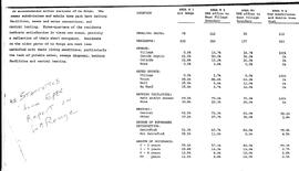
Table of statistics of housing in La Ronge, Sask. and area.
Part of R.M. Bone fonds
Statistics include dwelling units, number of residents, sewage and water source. Source: "Statistics from EPEC Report on La Ronge".
Bio/historical note:
Part of R.M. Bone fonds
Report [written by R.M. Bone] discusses three different types of communities - resiential, institutional and commercial.
Lots and Blocks in Air Ronge, Sask.
Part of R.M. Bone fonds
Part I - description of lot and block breakdown showing residents of Air Ronge. Part II - map indicating growth of Air Ronge.
Air Ronge Community Planners View.
Part of R.M. Bone fonds
Report [written by R.M. Bone] describes existing layout and future development of Air Ronge, Sask.
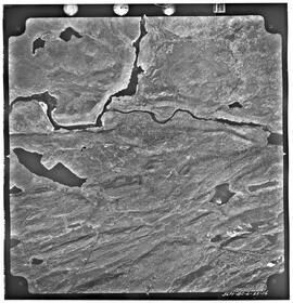
Aerial photo of Black Lake, Sask.
Part of R.M. Bone fonds
At bottom of image: "NW 1181071-1-2".
Bio/historical note:
Flight plan of La Ronge, Sask.
Part of R.M. Bone fonds
Map of flight plan for aerial photos of La Ronge; shows physical features; "C3-La Ronge and Air Ronge 1:5000 G 60521 20-5-76".
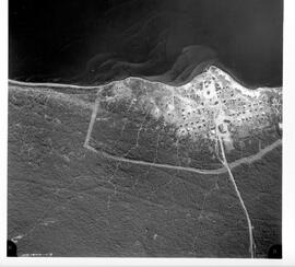
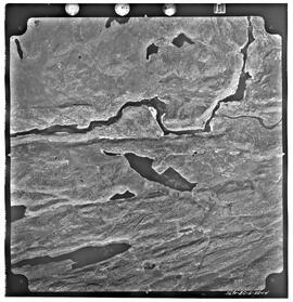
Aerial photo of Uranium City, Sask.
Part of R.M. Bone fonds
Series of 4 mosaic photos. At bottom of image: "5690-RC-6-22-16" On back of image: "Job P 1613/59 / Roll 5690 / Flight Altitude - 7000 feet AMSL / Focal Length - 152.53 mm / Date of Photography - May 30 1960 / Time (GMT) HRS / Photography by Hunting Survey Corporation Limited Toronto, Canada / Copyright - The Province of Saskatchewan Department of Highways"
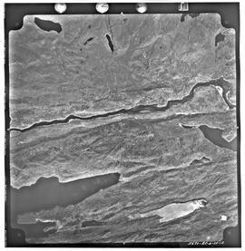
Aerial photo of Uranium City, Sask.
Part of R.M. Bone fonds
Series of 4 mosaic photos. At bottom of image: "5690-RC-6-22-14" On back of image: "Job P 1613/59 / Roll 5690 / Flight Altitude - 7000 feet AMSL / Focal Length - 152.53 mm / Date of Photography - May 30 1960 / Time (GMT) HRS / Photography by Hunting Survey Corporation Limited Toronto, Canada / Copyright - The Province of Saskatchewan Department of Highways"
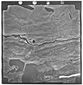
Aerial photo of Uranium City, Sask.
Part of R.M. Bone fonds
Series of 4 mosaic photos. At bottom of image: "5690-RC-6-22-12" On back of image: "Job P 1613/59 / Roll 5690 / Flight Altitude - 7000 feet AMSL / Focal Length - 152.53 mm / Date of Photography - May 30 1960 / Time (GMT) HRS / Photography by Hunting Survey Corporation Limited Toronto, Canada / Copyright - The Province of Saskatchewan Department of Highways"
Aerial photo of Uranium City, Sask.
Part of R.M. Bone fonds
Series of 4 mosaic photos. At bottom of image: "5690-RC-6-22-10" On back of image: "Job P 1613/59 / Roll 5690 / Flight Altitude - 7000 feet AMSL / Focal Length - 152.53 mm / Date of Photography - May 30 1960 / Time (GMT) HRS / Photography by Hunting Survey Corporation Limited Toronto, Canada / Copyright - The Province of Saskatchewan Department of Highways"