- A-9722
- Item
- May 1969
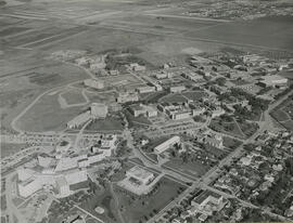
View facing north with east side residential districts and campus buildings in foreground; north end residential district and prairie in background.
376 resultados com objetos digitais Mostrar resultados com objetos digitais
View facing north with east side residential districts and campus buildings in foreground; north end residential district and prairie in background.
View looking west at Physical Education Building, Engineering Building, and University (Main( Barn near centre of image. Protein, Oil and Starch (POS) Pilot Plant, Varsity View residential areas and College Drive runs at lleft, South Saskatchewan River and west side residential areas visible in background.
View looking northeast with College Drive and east side residential areas running along bottom of image. All of campus visible.
View looking north with Griffiths Stadium in foreground; South Saskatchewan River and northern residential areas in background. College Drive runs along bottom of image.
View looking west with farm land in foreground; most campus buildings visible. College Drive runs along top left side of image.
View looking east of campus, with University Hospital laundry facility in foreground; construction of Law-Commerce-Arts Addition visible in background.
View looking northwest of campus, with University (Main) Barn and Physical Education Building in foreground. The Bowl and Arts Tower visible in background, with surrounding buildings. College Drive runs along the left of image; river and west side of city visible in background.
View looking east of campus, with river and riverbank in foreground. University Hospital at centre of image, with surrounding buildings. College Drive runs down right side of image.
View looking northeast of campus, with President's Residence in foreground. Arts Tower at centre of image, with surrounding buildings. College Drive runs along right side of image, to the prairie in background.
Looking east with South Saskatchewan River and land in foreground; Arts Tower at centre.
View facing southeast showing construction of Arts Building Tower, and the Thorvaldson addition of the Chemistry Building. University Hospital in foreground; the Bowl and surrounding buildings at centre of image.
View facing west of the Linear Accelerator Building at left; the Bowl and surrounding buildings at centre.
View facing west with University (Main) Barn and feed (grain) elevator in foreground. The Bowl and surrounding buildings at centre; west side of city and bridge in background.
View looking northwest with College Drive running along bottom of image. Physical Education Building prominent in foreground; river and view of city in background.
View looking northeast with University Hospital visible at bottom left of image. College Drive runs along the bottom at right; Sutherland visible at top.