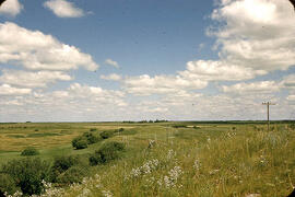
Ice-contact gravel ridge - northeast of Lampman, Saskatchewan
- WOK 3-49
- Stuk
- 1954
Part of W.O. Kupsch fonds
Ice-contact gravel ridge (minor end moraine?) - northeast of Lampman, Saskatchewan.
Zonder titel
21 results with digital objects Show results with digital objects
Ice-contact gravel ridge - northeast of Lampman, Saskatchewan
Part of W.O. Kupsch fonds
Ice-contact gravel ridge (minor end moraine?) - northeast of Lampman, Saskatchewan.
Zonder titel
Index map of southwestern Saskatchewan
Part of W.O. Kupsch fonds
Index map of southwestern Saskatchewan and adjacent regions showing the Dollard area.
Drumlinized kame - Wright's gravel pit
Part of W.O. Kupsch fonds
Drumlinized kame, partly excavated. Wright's gravel pit east of highway 13 near Eastend, Sask. Looking at stoss end.
Experimental formation of drumlin
Part of W.O. Kupsch fonds
Experimental formation of drumlin.
Spillway. Black Strap Coulee south of Saskatoon, Sask
Part of W.O. Kupsch fonds
Spillway. Black Strap Coulee south of Saskatoon, Sask.
Sand and gravel in a glacier drainage channel
Part of W.O. Kupsch fonds
Sand and gravel in a glacier drainage channel as a source for asphalt-road material. Near Chamberlain, Sask.
South Saskatchewan River at Elbow
Part of W.O. Kupsch fonds
South Saskatchewan River at Elbow.
Glacial drainage channel - Moosomin Dam, Sask
Part of W.O. Kupsch fonds
Glacial drainage channel - Moosomin Dam, Sask.
Slump block, east bank of Souris, south of Oxbow, Sask
Part of W.O. Kupsch fonds
Slump block, east bank of Souris, south of Oxbow, Sask.
Terraces along Moose Mountain Creek
Part of W.O. Kupsch fonds
Terraces along Moose Mountain Creek, looking south. Note Horse Hills (kames) in back.
Fill terrace south of Oxbow, Sask
Part of W.O. Kupsch fonds
Fill terrace south of Oxbow, Sask.
Esker near Skull Creek, Tompkins, Sask.
Part of W.O. Kupsch fonds
Esker near Skull Creek, Tompkins, Sask.
Esker in eskerine complex - view from the side
Part of W.O. Kupsch fonds
Esker in eskerine complex near Stoughten, Sask. View from the side. Notice sinuous crest line, boulders.
Part of W.O. Kupsch fonds
Large erratic of granodiorite along road about 215 miles south of La Ronge, Sask.
Close-up of mud plaster - near St. Louis, Sask.
Part of W.O. Kupsch fonds
Close-up of mud plaster showing grooves in matrix and striations on boulders in mud plaster deposited on till along west bank of South Saskatchewan River near St. Louis, Sask.