Area of the Netherlands affected by flood on 31 January, 1931
- WOK 1-27
- Item
- [1952-1954]
Part of W.O. Kupsch fonds
Map of the Netherlands showing the principle areas affected by the flood disaster of the 31 January, 1953.
12 results with digital objects Show results with digital objects
Area of the Netherlands affected by flood on 31 January, 1931
Part of W.O. Kupsch fonds
Map of the Netherlands showing the principle areas affected by the flood disaster of the 31 January, 1953.
Part of Town Collection
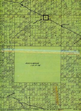
A green land title map covering the grid from Rge.10 Twp. 15 to Rge.12 Twp. 18. Within the grid are the towns of Sintaluta and Wolseley as well as Carry The Kettle (Ce-Ga-Kin) Reserve .
Extent of flooding in southwestern Netherlands
Part of W.O. Kupsch fonds
Map of southwestern Netherlands the extent of flooding. Map copied from a book.
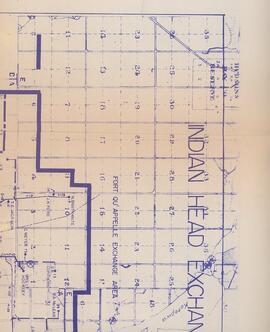
Indian Head Area Telephone Exchange Map (1975)
Part of Businesses Collection
Map of the Indian Head Area Telephone Exchange showing the boundaries of all the independent rural telephone companies within the Indian Head Exchange Area from 1902 revised and updated to 1975. These consisted of Wide Awake Rural Telephone Company; Arcadia RTC; Rose Valley RTC; Fair Play RTC; Squirrel Hill RTC; Sunny South RTC; Deep Lake RTC
Saskatchewan Government Telephones
Indian Head Area Telephone Exchange Map (1979)
Part of Businesses Collection
An 83 cm by 75 cm map of the Indian Head Area Telephone Exchange showing the boundaries of all the independent rural telephone companies within the Indian Head Exchange Area from 1902 revised and updated to 1979. In 1975 (see IHM.2020.0187a), these consisted of Wide Awake Rural Telephone Company; Arcadia RTC; Rose Valley RTC; Fair Play RTC; Squirrel Hill RTC; Sunny South RTC; Deep Lake RTC. By 1979, three of the southern companies - Deep Lake RTC, Fair Play RTC and Squirrel Hills RTC had been turned over to SaskTel.
Saskatchewan Government Telephones

Part of Rural Municipality Collection
Map of Rural Municipality of Indian Head #156 including names of landowners
Indian Head, Rural Municipality No. 156

Part of Rural Municipality Collection
Map of Rural Municipality of Indian Head #156 including names of landowners
Indian Head, Rural Municipality No. 156

Part of Rural Municipality Collection
Map of Rural Municipality of Indian Head #156 including names of landowners
Indian Head, Rural Municipality No. 156

Part of Rural Municipality Collection
Map of Rural Municipality of Indian Head #156 including names of landowners
Indian Head, Rural Municipality No. 156

Part of Rural Municipality Collection
Map of Rural Municipality of Indian Head #156 including names of landowners
Indian Head, Rural Municipality No. 156

Part of Rural Municipality Collection
Map of Rural Municipality of Indian Head #156 including names of landowners
Indian Head, Rural Municipality No. 156

Part of Rural Municipality Collection
Map of Rural Municipality of Indian Head #156 including names of landowners
Indian Head, Rural Municipality No. 156

Part of Rural Municipality Collection
Municipality of North Qu'Appelle

Official Town of Indian Head map
Part of Town Collection
Map with all the streets and lot numbers of the Town of Indian Head
The Town of Indian Head