Aerial photograph of glacial grooves in unconsolidated sediments formed near the Souris spillway. These ridges were possiblu formed during the advances of the ice. Sec. 1, T. 4, R. 11, W. 2.
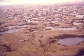
Aerial photograph of fluvial-lacustrine plain. Note washed appearance of the plain; also note small sand dune in the southern part of sec. 17. Sec. 17, R. 1, T. 17, W. 2.
Aerial photograph showing drumlins and ice-crack moraines in Cree Lake area. Note two sets of ridges which cross one another immediately notheast of the centre of the slide; crevasse filling crossing drumlin.
Aerial photograph of domal stream adjustment and annular stream pattern with tonal haloo around topographic high, which is coincident with seismic high. Braddock structure, Sask.