Aerial view of lacustrine plain
- WOK 2-91
- Item
- [1951-1957]
Part of W.O. Kupsch fonds
Aerial photograph of lacustrine plain. Note ill-defined ridges. Sec. 29, T. 9, R. 15, W. 2.
37939 results with digital objects Show results with digital objects
Aerial view of lacustrine plain
Part of W.O. Kupsch fonds
Aerial photograph of lacustrine plain. Note ill-defined ridges. Sec. 29, T. 9, R. 15, W. 2.
Part of W.O. Kupsch fonds
Aerial photograph of limy knolls. Calcium carbonate coming to the surface on the knolls giving them a light-coloured appearance probably formed due to erosion of the knolls. Sec. 13, T. 8, R. 7, W. 2.
Aerial view of linear drainage pattern along fault
Part of W.O. Kupsch fonds
Aerial photograph of linear drainage pattern along fault. Souris River Lowland near Estevan.
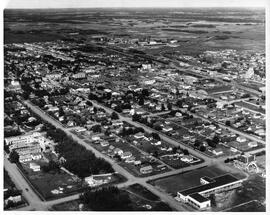
Part of Lloydminster Chamber of Commerce
Aerial view of Lloydminster, Saskatchewan and Alberta, looking northwest.
McGales Studio
Part of LRA Photograph Collection
Aerial view of Mackenzie River delta near Aklavik, N.W.T.
Part of W.O. Kupsch fonds
Aerial view of Mackenzie River delta near Aklavik, N.W.T.
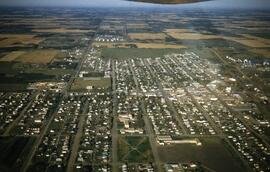
Aerial view of Maidstone in winter
Part of Saskatoon StarPhoenix fonds
Photograph shows an aerial view of Maidstone in winter, December 4, 1950.
Aerial view of meander in Ucayali River
Part of W.O. Kupsch fonds
Aerial view of meander in Ucayali River showing sand bar on slip-off slope. Flight Chicotza-Pucallpa.
Aerial view of Medical Building, University Hospital, and rest of campus
Part of Saskatoon StarPhoenix fonds
Photograph shows an aerial view of Medical Building, University Hospital, and rest of campus, December 31, 1954.
Part of City of Melfort collection
Aerial photo of part of Melfort and surrounding farm land. River in upper left with part of the manmade reservoir, the Hospital is in the lower right and the oval racetrack is on the right side.
Part of City of Melfort collection
An aerial view of Melfort and area. Saskatchewan Ave. is to the left.
Part of City of Melfort collection
An aerial view of Melfort and area. Saskatchewan Ave. is to the left.
A aerial view of Melfort and area from the northeast.
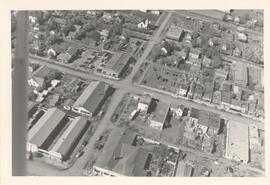
Aerial view of Melfort, Saskatchewan
Part of Melfort General Photo collection
Aerial view of Melfort Saskatchewan
Carson of Skyline
Aerial view of meltwater channel traversing dead ice moraine
Part of W.O. Kupsch fonds
Aerial photograph showing meltwater channel traversing dead ice moraine ("doughnut" pattern). Sec. 22, T. 6, R. 32, W. 2.