Mackenzie River and Nahanni Mountains, NWT.
- INS-394
- Item
- [ ca. 1928]
File note: Between Fort Simpson and Fort Wrigley, NWT.
6 results with digital objects Show results with digital objects
Mackenzie River and Nahanni Mountains, NWT.
File note: Between Fort Simpson and Fort Wrigley, NWT.
Midnight on the Mackenzie at the Ramparts [NWT]
File notes: South of Fort Good Hope.
File note: Between Fort Simpson and Fort Good Hope, NWT.
Oil well of Fort Norman Oil Co. 30 miles below Fort Norman, NWT.
Part of Fort Chipewyan, Alberta., from Mission Rock.
Part of Fort Chipewyan, Alberta., from the government wharf.
Police huskies at Fort Resolution, NWT.
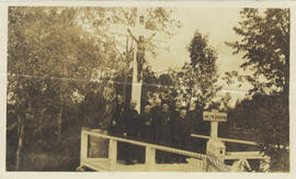
Priests posing under a Calvary cross. Lac Ste. Anne, Alberta.
Ramparts south of Fort Good Hope, NWT.
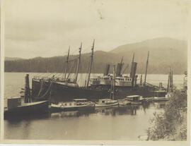
Ships in Prince Rupert harbour with the 'C.E. Foster' in the foreground. Prince Rupert, BC.
Tar Sand Bank on Hangingstone Creek [Alberta]
Tar Sand bank on Hangingstone Creek; image taken from bridge. Probably taken in 1928. Note inside file states: "Flows into Clearwater River, 56 degrees 43 minutes North - 111 degrees 20 minutes West." Prof. Emrys Jones donated a large collection of early northern photographs to the Institute for Northern Studies in 1968.
The Escarpment of the Nahanni Mountains, NWT.
File note: Between Fort Simpson and Fort Good Hope, NWT.