- ZE2.006
- Item
- [1993]
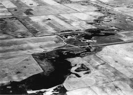
An aerial view of the Blind Creek near Zealandia flooding in the spring. The water flowed west to east and met up with the South Saskatchewan River near Saskatoon.
376 results with digital objects Show results with digital objects
An aerial view of the Blind Creek near Zealandia flooding in the spring. The water flowed west to east and met up with the South Saskatchewan River near Saskatoon.
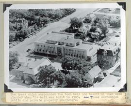
Aerial view and grounds the Yorkton Town hall
Part of Howard Jackson Collection
The trees and lawn which surrounded the Town hall
Aerial photograph: A 12575-249
Part of W.O. Kupsch fonds
Aerial photograph: A 12575-249. Same as slide 120, stereo pair.
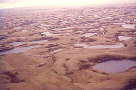
Aerial view of dead ice moraine - effects of lowered water level
Part of W.O. Kupsch fonds
Aerial view of dead ice moraine showing the effects of lowered water level in ponds; Western part of Moose Mountain, Saskatchewan.
Kupsch, Walter Oscar
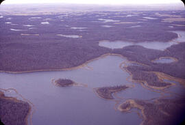
Aerial view of dead ice moraine - effects of lowered water level
Part of W.O. Kupsch fonds
Aerial view of dead ice moraine showing the effects of lowered water level in ponds; Western part of Moose Mountain, Saskatchewan
Kupsch, Walter Oscar
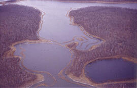
Aerial view of dead ice moraine with knob and kettle topography
Part of W.O. Kupsch fonds
Aerial view of dead ice moraine with knob and kettle topography; Western part of Moose Mountain, Saskatchewan.
Kupsch, Walter Oscar
Aerial view of northern Baffin Island
Part of W.O. Kupsch fonds
Citation reads: "Aerial view of nice cap in distance, fiords in foreground, northern Baffin Island, August 16, 1965."
Aerial view of settlement, Aklavik, N.W.T.
Part of W.O. Kupsch fonds
Citation reads: "Aerial view of settlement, Aklavik, N.W.T. August 22, 1965."
Aerial view of settlement, Inuvik, N.W.T.
Part of W.O. Kupsch fonds
Citation reads: "Aerial view of settlement, Inuvik, N.W.T. August 22, 1965."
Aerial view of northern Baffin Island
Part of W.O. Kupsch fonds
Citation reads: "Aerial view of northern Baffin Island, August 16, 1965."
Part of W.O. Kupsch fonds
Citation reads: "General view of mining camp, Mary River, N.W.T. August 15, 1965."
Rubber boats dropped by plane in rescue operations
Part of W.O. Kupsch fonds
Aerial photograph of rubber boats being used to rescue people during flood.
Water flowing through damaged dikes
Part of W.O. Kupsch fonds
Aerial photograph of water streaming with great force through two gaps in the dikes.
Rescuing people from trees after flood
Part of W.O. Kupsch fonds
Aerial photograph shows a helicopter rescuing people from trees after flooding. Can also see the damage to the dike in the background.
Flooding of Brouwershaven, island of Schouwen
Part of W.O. Kupsch fonds
Aerial photograph shows the flooded areas in the surroundings of Brouwershaven, island of Schouwen. Can see only the tops of fencelines and roofs of buildings.