
Aerial photo of Uranium City, Saskatchewan
- A. General files. Uranium City. Air photos, Uranium City and El Dorado - 1959-1960.
- Item
- June 6, 1960
Parte deR.M. Bone fonds
Aerial view of Uranium City, Saskatchewan.
Sin título
6 resultados con objetos digitales Muestra los resultados con objetos digitales
Aerial photo of Uranium City, Saskatchewan
Parte deR.M. Bone fonds
Aerial view of Uranium City, Saskatchewan.
Sin título
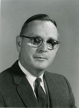
Head and shoulders image of J. Howard Richards, Professor and Head, Department of Geography.
Bio/Historical Note: J. Howard Richards was born 21 May 1916 in Caerphilly, Wales. He enrolled at the University of Wales in 1934 and graduated in 1938 with a B.Sc. in Geography. Richards remained in Wales the following year to teach at a private school and spent the next two years as a Meteorologist in the United Kingdom and Canada. He joined the Royal Canadian Army, serving in Europe from 1942-1946. After his discharge, Richards enrolled at the University of Toronto; in 1947 he received his MA. Richards taught at Utica College of Syracuse University and the University of Manitoba before returning to the University of Toronto, where he earned his PhD in 1956. He briefly joined the staff of the Royal Military College of Canada prior to coming to the University of Saskatchewan in 1960 as Professor and Head of the newly formed Department of Geography. He was to remain in that post until his retirement in 1979. He was named Professor Emeritus in 1983. During his tenure, Richards developed academic programs in Geography and the interdisciplinary programs of Land Use, Environmental Studies and Regional and Urban Development and Planning. He was the editor of the first "Atlas of Saskatchewan" and the author of "Saskatchewan Geography" and "Saskatchewan: A Geographical Appraisal," among other publications.
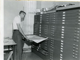
J.C. McConnell, instructor in Geography and Librarian for the Land Use Mapping Project, checks the accuracy of maps made from air photo interpretations.
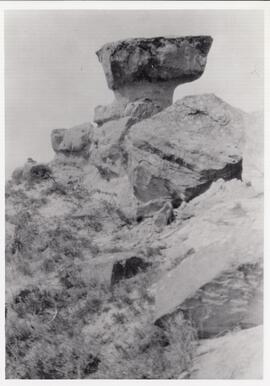
The rock formation that gave Rockglen, Saskatchewan its name.
Parte deMJ General Photograph Collection
Photograph of the local rock formation which gave the town of Rockglen, Saskatchewan its name. It was later removed as it was considered dangerous.
Map of the Netherlands, 16th century
Parte deW.O. Kupsch fonds
Map of the Netherlands during the 16th century. Shows the land area and drainage channels.
A section of Polderland, Holland
Parte deW.O. Kupsch fonds
Map of a section of Polderland, Holland. Map copied from a book.
Dune erosion from gales , North of Bergen aan Zee
Parte deW.O. Kupsch fonds
Aerial photograph showing the gaps in dunes caused by violent gales, North of Bergen aan Zee.
Outcrop of "Athabasca tar sand" - pit of Abasand quarry
Parte deW.O. Kupsch fonds
Outcrop of "Athabasca tar sand" (McMurray formation of Lower Cretaceous age) in a pit of Abasand quarry near McMurray, Alberta.
Air photograph of McMurray, Alberta
Parte deW.O. Kupsch fonds
Aerial photograph of McMurray, Alberta.
Swash marks on Peter Pond Lake
Parte deW.O. Kupsch fonds
Swash marks on Peter Pond Lake (Big Buffalo) Lake beach at Sandy Point, Saskatchewan
Mission Canyon, Little Rocky Mountains, Montana
Parte deW.O. Kupsch fonds
Mission Canyon, Little Rocky Mountains, Montana.
Ironstone concretions in Eagle sandstone
Parte deW.O. Kupsch fonds
Ironstone concretions in Eagle sandstone. Morriosn Dome, Little Rocky Mountains, Montana.
Kepperlites sp. Rierdon formation. Morrison Dome.
Parte deW.O. Kupsch fonds
Kepperlites sp. Rierdon formation. Morrison Dome, Montana.
Badlands. Fort Union formation. Paleocene
Parte deW.O. Kupsch fonds
Badlands. Fort Union formation (Paleocene). Theodore Roosevelt Park, N.D. Sign explaining the origin.
Badlands. Fort Union formation. Paleocene
Parte deW.O. Kupsch fonds
View of the Badlands. Fort Union formation (Paleocene). Theodore Roosevelt Park, N.D