Aligned coal pebbles and streaks in till - Eastend, Sask
- WOK 2-138
- Item
- 1954
Parte deW.O. Kupsch fonds
Aligned coal pebbles and streaks in till. Dempster's clay pit, Eastend, Sask.
27 resultados con objetos digitales Muestra los resultados con objetos digitales
Aligned coal pebbles and streaks in till - Eastend, Sask
Parte deW.O. Kupsch fonds
Aligned coal pebbles and streaks in till. Dempster's clay pit, Eastend, Sask.
Sangamon gravel and underlying till
Parte deW.O. Kupsch fonds
Sangamon gravel and underlying till. West of Fort Qu-Appelle, Sask.
Steeply dipping sands and gravels - Pipestone Creek, Sask
Parte deW.O. Kupsch fonds
Steeply dipping sands and gravels, faulted, in ice contact deposit probably overridden by ice. At crossing of highway 9 and Pipestone Creek, Sask
Fluvial sand and gravel overlying till - south of Eastend, Sask
Parte deW.O. Kupsch fonds
Fluvial sand and gravel (at base) overlying till. Coal pebbles in gravel (coal transported from Whitemud or Ravenscrag). South of Eastend, Sask.
Sand filled ice-wedge in till near Wolf Point, Montana
Parte deW.O. Kupsch fonds
Sand filled ice-wedge in till near Wolf Point, Montana.
Parte deW.O. Kupsch fonds
Washboard moraine looking east along east boundary of Sec. 29, T. 13, R. 2, W. 3.
Length of view of linear till ridge
Parte deW.O. Kupsch fonds
Length of view of linear till ridge (crevasse filling), near Shaunavon, Sask.
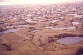
Aerial view of dead ice moraine with knob and kettle topography
Parte deW.O. Kupsch fonds
Aerial view of dead ice moraine with knob and kettle topography; Western part of Moose Mountain, Saskatchewan.
Sin título
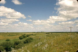
Aerial view of dead ice moraine - near Lampman, Sask
Parte deW.O. Kupsch fonds
Aerial view of dead ice moraine - near Lampman, Sask.
Kames. Lost Horse Hills west of Handsworth, Sask
Parte deW.O. Kupsch fonds
Kames. Lost Horse Hills west of Handsworth, Sask.
Ice-contact gravel ridge - northeast of Lampman, Saskatchewan
Parte deW.O. Kupsch fonds
Ice-contact gravel ridge (minor end moraine?) - northeast of Lampman, Saskatchewan.
Sin título
Index map of southwestern Saskatchewan
Parte deW.O. Kupsch fonds
Index map of southwestern Saskatchewan and adjacent regions showing the Dollard area.
Drumlinized kame - Wright's gravel pit
Parte deW.O. Kupsch fonds
Drumlinized kame, partly excavated. Wright's gravel pit east of highway 13 near Eastend, Sask. Looking at stoss end.
Experimental formation of drumlin
Parte deW.O. Kupsch fonds
Experimental formation of drumlin.