Kepperlites sp. Rierdon formation. Morrison Dome.
- WOK 1-91
- Item
- 1953
Part of W.O. Kupsch fonds
Kepperlites sp. Rierdon formation. Morrison Dome, Montana.
27 results with digital objects Show results with digital objects
Kepperlites sp. Rierdon formation. Morrison Dome.
Part of W.O. Kupsch fonds
Kepperlites sp. Rierdon formation. Morrison Dome, Montana.
Large boulder in finer gravel. Flaxville formation
Part of W.O. Kupsch fonds
Large boulder in finer gravel. Flaxville formation. Near Orpheim, Montana.
Badlands. Fort Union formation (Paleocene)
Part of W.O. Kupsch fonds
Badlands. Fort Union formation (Paleocene). Theodore Roosevelt Park, N.D.
Badlands. Fort Union formation. Paleocene
Part of W.O. Kupsch fonds
Badlands. Fort Union formation (Paleocene). Theodore Roosevelt Park, N.D. Sign explaining the origin.
Badlands. Fort Union formation. Paleocene
Part of W.O. Kupsch fonds
View of the Badlands. Fort Union formation (Paleocene). Theodore Roosevelt Park, N.D
Little Missouri River in Badlands, Theodore Roosevelt Park
Part of W.O. Kupsch fonds
Badlands in Theodore Roosevelt Park, N.D showing Little Missouri River
Missouri River near Wolf Point, Montana
Part of W.O. Kupsch fonds
Missouri River near Wolf Point, Montana. Fort Union (Paleocene) highland in background. Identity of individuals in photograph unknown.
Clastic dike in Flaxville formation
Part of W.O. Kupsch fonds
Clastic dike in Flaxville formation (Miocene-Pliocene), Near Orpheim, Montana. IDentity of individual in photograph unknown.
Collapse of overburden over burning coal seam
Part of W.O. Kupsch fonds
Collapse of overburden over burning coal seam. Fort Union formation (Paleocene). Near Amidon, N.D. Identity of individuals in the photograph is unknown.
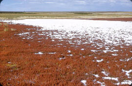
"Alkali" salt flat near Cantuar, Saskatchewan
Part of W.O. Kupsch fonds
"Alkali" salt flat at shore of a saline lake near Cantuar, Saskatchewan; note abundance of salt wort (Salicornia rubra).
Kupsch, Walter Oscar
Salt wort growing on "alkali" salt flat
Part of W.O. Kupsch fonds
Salt wort ('Salicornia rubra') growing on "alkali" salt flat. Near Cantuar, Saskatchewan Tuesday September 13, 1960.
Swift Current Creek section along north side of tributary
Part of W.O. Kupsch fonds
Swift Current Creek section along north side of tributary to Swift Current Creek in Sec. 10, T. 19, R. 13, W. 3 meridian. From bottom to top: Wymark Till (buff), Lower stratified drift (white band), Aikins Till (grey), Middle stratified drift (light buff), Leinan Till (dark buff). Depth of valley is about 150 feet. Tuesday September 13, 1960. Note: For general views see 45_14,15.
Close up contact between middle stratified drift and Leinan Till
Part of W.O. Kupsch fonds
Close up contact between middle stratified drift and Leinan Till. Lower part of Middle stratified drift is covered by slope wash. Swiift Current Creek section along north sside of tributary to Swift Current Creek in Sec. 10, T. 19, R. 13, W. 3 meridian. Tuesday September 13, 1960.
Lower stratified drift Swift Current Creek section
Part of W.O. Kupsch fonds
Lower stratified drift Swift Current Creek section along north side of tributary to Swift Current Creek in Sec. 10, T. 19, R. 13, W. 3 meridian. At this place the Lower stratified drift may possible represent a weathered till (cf. Wickenden 1931 C, Sec. C) as it is not stratified, non-sorted, contains some erratics, is highly calcareous but is not a marl (organic, mainly algal, deposit) as Christiansen (1959) reported. Spade is placed on gradational zone from Wymark Till to Lower Stratified drift. Peter David holds hand on sharp contact between Lower stratified drift and AIkins Till. Tuesday September 13, 1960.
The bedrock formations of Iceland
Part of W.O. Kupsch fonds
The bedrock formations of Iceland. Palagonite Formation = Moberg Formation Older Series = Old Grey Basalts. Younger Series = Moberg Mountains and Young Grey Basalts