Map of oil and gas seeps in Middle East
- WOK 1-2
- Item
- [1952-1954]
Part of W.O. Kupsch fonds
Map of oil and gas seeps in the Middle East. Map copied from a book.
20 results with digital objects Show results with digital objects
Map of oil and gas seeps in Middle East
Part of W.O. Kupsch fonds
Map of oil and gas seeps in the Middle East. Map copied from a book.
Boarding plane in Rankin Inlet
Part of W.O. Kupsch fonds
Citation reads: Boarding plane. A.W.R. Carrothers at far left, Rankin Inlet, N.W.T. August 3, 1965.
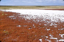
"Alkali" salt flat near Cantuar, Saskatchewan
Part of W.O. Kupsch fonds
"Alkali" salt flat at shore of a saline lake near Cantuar, Saskatchewan; note abundance of salt wort (Salicornia rubra).
Kupsch, Walter Oscar
Glazed, baked Arabian handgrenade
Part of W.O. Kupsch fonds
Photograph of a glazed and baked Arabian handgrenade filled with inflammable or burning mixtures used in war. Photograph copied from a book.
Dune erosion from gales , North of Bergen aan Zee
Part of W.O. Kupsch fonds
Aerial photograph showing the gaps in dunes caused by violent gales, North of Bergen aan Zee.
Area of the Netherlands affected by flood on 31 January, 1931
Part of W.O. Kupsch fonds
Map of the Netherlands showing the principle areas affected by the flood disaster of the 31 January, 1953.
Cut through the watertank at Mohenjo Daro
Part of W.O. Kupsch fonds
Diagram of a cut through an excavated watertank at Mohenjo Daro. Diagram copied from a book.
The wall of watertank at Mohenjo Daro
Part of W.O. Kupsch fonds
Photograph of a watertank at Mohenjo Daro. Shows bituminous layer. Photograph copied from a book.
Excavated watertank in front of temple at Mohenjo Daro, Indus Valley
Part of W.O. Kupsch fonds
Photograph of a watertank in front of excavated temple at Mohenjo Daro. Oldest known use of bitumen as a damp cource, 3,000 BC. Photograph copied from a book.
Map of oil fields in Pakistan-India-Burma, after Landes
Part of W.O. Kupsch fonds
Map of oil fields in Pakistan-India-Burma. Map copied from a book.