Map showing extent of present permafrost
- WOK 4-130
- Item
- [1948-1957]
Parte deW.O. Kupsch fonds
Map showing extent of present permafrost (Black, 1954, fig. 1).
21 resultados con objetos digitales Muestra los resultados con objetos digitales
Map showing extent of present permafrost
Parte deW.O. Kupsch fonds
Map showing extent of present permafrost (Black, 1954, fig. 1).
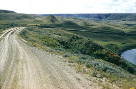
Preglacial Neidpath channel, gentle slopes, wide valley
Parte deW.O. Kupsch fonds
Preglacial Neidpath channel, gentle slopes, wide valley.
Slumping in valley of Swift Current Creek
Parte deW.O. Kupsch fonds
Slumping in valley of Swift Current Creek in western Saskatchewan
Sin título
Slumping in valley of Swift Current Creek
Parte deW.O. Kupsch fonds
Slumping in valley of Swift Current Creek.
Parabolic blow-out dune - Great Sand Hills area
Parte deW.O. Kupsch fonds
Inside of parabolic blow-out dune, Great Sand Hills area in sec. 29, T. 16, R. 21, W. 3. Notice the gentle depositional slope along central axis to left, steep erosional slopes on side of U.
View in direction of wind into blow-out dune - Great Sand Hills
Parte deW.O. Kupsch fonds
A view in the direction of the wind into blow-out dune, Great Sand Hills area in sec. 29, T. 16, R. 21, W. 3.
Outside view of distal end of parabolic dune - Great Sand Hills area
Parte deW.O. Kupsch fonds
Outside view of distal end of parabolic dune; Great Sand Hills area in sec. 29, T. 16, R. 21, W. 3.
Exposure of till - Dempster's clay pit, Eastend, Sask
Parte deW.O. Kupsch fonds
Exposure of till. Vertical markings made by bulldozer. Dempster's clay pit, Eastend, Sask. (Stu Jordan in picture)
Parte deW.O. Kupsch fonds
Crevasse filling near Wymark.
Rills cut into wall of Cypress Hills gravels
Parte deW.O. Kupsch fonds
Rills cut into wall of Cypress Hills gravels, located between ridges of gravel due to bulldozing on top. Notice resemblance to jointing. Two persons on top.
Rills cut into wall of Cypress Hills gravels
Parte deW.O. Kupsch fonds
Rills cut into wall of Cypress Hills gravels, located between ridges of gravel due to bulldozing. View of the bull-dozed ridges on top. Stu Jordan in picture.
Topographic and vegetational lineament
Parte deW.O. Kupsch fonds
Topographic and vegetational lineament in N.E. quarter sec. 1, T. 16, R. 15, W. 3. Stu Jordan and car in picture.
Pediment developed across slump blocks
Parte deW.O. Kupsch fonds
Pediment developed across slump blocks. Alluvial fan cut by Frenchman Creek to the left. Neighbor, Sask.
Remains of mammoth tooth found near Wiseton, Sask
Parte deW.O. Kupsch fonds
Remains of mammoth tooth found near Wiseton, Sask. From upper left to lower right: tusk, rught ulna, left femur,left ulna, thoracic vertebra
Crevasse fillings - post glacial stream pattern adjusted to till pattern
Parte deW.O. Kupsch fonds
Crevasse fillings - post glacial stream pattern adjusted to till pattern (?). Thin aeolian sand pver till. Location: sec. 4, T. 16, R. 14, W. 3, Sask.