- A-10083
- Item
- Sept. 1979
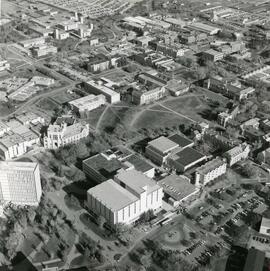
View looking northwest with the Bowl and surrounding campus buildings at centre.

230 resultados com objetos digitais Mostrar resultados com objetos digitais
View looking northwest with the Bowl and surrounding campus buildings at centre.
Looking northwest at Diefenbaker Canada Centre with Education Building in background.
View looking northeast of campus buildings, with the Bowl at centre.
View looking north of campus buildings, with College Drive running along bottom of image. Prairie fields and Preston Avenue in background.
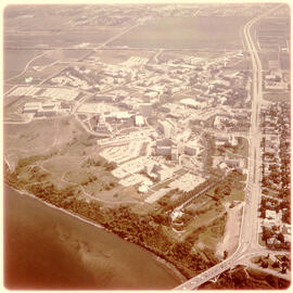
Looking northeast at campus with South Saskatchewan River and 25th Street (University) Bridge in foreground.
H.D. "Howdy" McPhail Photograph Collection
This collection includes Howdy McPhail’s aerial photographs, predominantly of individual farms and views of towns and cities. Some images are of specific landmarks, scenic views, or fauna. All images are identified and a majority are dated. A second accrual contains examples of printed calendars and postcards that were sold by McPhail, as well as some correspondence and other business documentation. Images used in an exhibition curated by Helen Marzolf were added in 2018. Further accruals of correspondence, order forms, negatives and prints were interfiled in Series B.
Sem título
View looking east with Arts Tower at centre of image; river and 25th Street Bridge in foreground. College Drive and east side residential areas run along right side of image.
View looking southwest with Preston Avenue and University land in foreground; the Bowl and Arts Building with surrounding buildings at centre.
View looking west with Rutherford Rink at centre of image; campus buildings in foreground. College Drive runs along left of photograph. 25th Street Bridge, river and west side in background.
View looking northwest with Griffiths Stadium and University land in foreground. University Hospital and surrounding buildings at centre of image; South Saskatchewan River, 25th Street Bridge, and city in background. College Drive runs through centre.
View looking southwest with Arts Tower at centre, with surrounding campus buildings in foreground. 25th Street Bridge, South Saskatchewan River and west side in background.
View looking west of campus buildings at centre; University (25th Street Bridge), river, and west side residential areas in background. College Drive runs along left of image, and Preston Avenue runs along bottom.
View of looking north campus buildings at centre, with east side residential area and Griffiths Stadium partially visible in foreground. College Drive runs along bottom of image, with University lands and prairie in background.
View of campus at centre; South Saskatchewan River and 25th Street Bridge at bottom; University lands and Sutherland in background. College Drive running at right of image.
View of College Drive and east side residential areas at bottom of image. Campus at centre, with University lands and Sutherland in background.