Scaling of weathered tombstone of mica schist
- WOK 2-80
- Pièce
- 1957
Fait partie de W.O. Kupsch fonds
Scaling of weathered tombstone of mica schist. Cemetery of Trinity Church, Broadway, Manhattan, N.Y.

76 résultats avec objets numériques Afficher les résultats avec des objets numériques
Scaling of weathered tombstone of mica schist
Fait partie de W.O. Kupsch fonds
Scaling of weathered tombstone of mica schist. Cemetery of Trinity Church, Broadway, Manhattan, N.Y.
This fonds contains reference material, correspondence, reports, manuscripts, maps and research data relating to Dr. Chakravarti's research, teaching, and administrative career. Included are correspondence relating to, and manuscripts of, many of Chakravarti's published articles. Dr. Chakravarti has published widely in the following fields: synoptic climatology; precipitation patterns, drought and dust storms on the Canadian prairies; and agricultural and foods problems in India. The administrative series contains material relating to the restructuring of the Geography graduate program in the 1980s and to the appointments made in the department. The teaching series includes lecture notes, exams and assignments, and student evaluations.
Sans titre
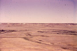
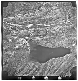
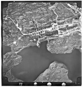
Meandering River in Frenchman Valley near Watson's Bridge
Fait partie de W.O. Kupsch fonds
Meandering River in Frenchman Valley near Watson's Bridge looking south; one can also see the prominent white band: Whitebud formation (Upper Cretaceous)
Sans titre

Fait partie de University of Saskatchewan Photograph Collection
From l to r: Jim Randall, head of Geography; Dr. Ka-iu Fung, Atlas editor; Maynard Sonntag, Saskatchewan Minister of Post-Secondary Education and Skills Training; and Peter MacKinnon, University President, admire the just-released second edition of The Atlas of Saskatchewan.
Bio/historical note: Image appeared in Oct. 1, 1999 OCN.
This fonds contains materials primarily related to Moss's work on the soil survey of Saskatchewan, and academic work connected to soil classification and land use.
Sans titre
This fonds contains material created or collected by Dr. Williamson during his varied career as an anthropologist, civil servant, legislator, professor, and as a consultant for various provincial, national and international organizations and governments. Although primarily documenting Dr. Williamson's work for and with the Inuit of northern Canada, this fonds includes material relating to all circumpolar countries, other aboriginal groups in Canada, international affairs, and a very broad range of topics as they relate to the north, including art and culture, physical geography, sport, environment, botany, zoology, economics, defence, etc. It includes his personal and professional correspondence, research data, articles and scholarly writing, as well as a substantial collection of reference publications.
Sans titre
This fonds consists primarily of material from two studies in which Dr. Bone was associated. The earliest, the "Stony Rapids Project", was conducted while Bone was in the Department of Geography. It started with a small grant from the Canadian Wildlife Service to examine the caribou hunt; ie. the number of people involved and the number of animals taken. The project, however, grew to encompass a wider study of the region and its inhabitants. The second study was undertaken while Bone was with the Institute of Northern Studies (INS). The Northern Saskatchewan Housing Needs Survey was a co-operative effort between the Department of Northern Saskatchewan and the Northern Municipal Council. The primary focus was to investigate the housing needs of the Métis in northern Saskatchewan. The INS was subcontracted to oversee the project, train the surveyors, enter the data, and write the final report. The resulting survey was more than an examination of housing needs. It also contains a great deal of socio-economic data which resulted in one of the most exhaustive studies of its kind. The fact that the surveyors came from the communities studied explains much of the data collection success. Both of these projects offer a unique snapshot of the communities studied. There is also material of a more general nature that deals with northern Saskatchewan, Alberta, Manitoba, and the Yukon and Northwest Territories.
Sans titre
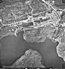
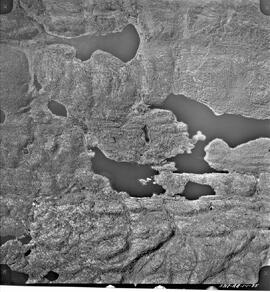
Aerial photo of Uranium City, Sask.
Fait partie de R.M. Bone fonds
Series of 43 mosaic photos. At bottom of image: "5717-AB-1-1-7" On back of image: "Job P 1613/59 / Roll 5717 / Flight Altitude - 7000 feet AMSL / Focal Length - 152.53 mm / Date of Photography - June 6 1960 / Time (GMT) 1220-1225 HRS / Photography by Hunting Survey Corporation Limited Toronto, Canada / Copyright - The Province of Saskatchewan Department of Highways"
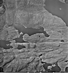
Aerial photo of Uranium City, Sask.
Fait partie de R.M. Bone fonds
Series of 43 mosaic photos. At bottom of image: "5717-AB-1-1-17" On back of image: "Job P 1613/59 / Roll 5717 / Flight Altitude - 7000 feet AMSL / Focal Length - 152.53 mm / Date of Photography - June 6 1960 / Time (GMT) 1220-1225 HRS / Photography by Hunting Survey Corporation Limited Toronto, Canada / Copyright - The Province of Saskatchewan Department of Highways"
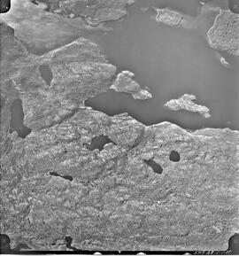
Aerial photo of Uranium City, Sask.
Fait partie de R.M. Bone fonds
Series of 43 mosaic photos. At bottom of image: "5717-AB-1-1-29" On back of image: "Job P 1613/59 / Roll 5717 / Flight Altitude - 7000 feet AMSL / Focal Length - 152.53 mm / Date of Photography - June 6 1960 / Time (GMT) 1220-1225 HRS / Photography by Hunting Survey Corporation Limited Toronto, Canada / Copyright - The Province of Saskatchewan Department of Highways"

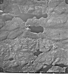
Aerial photo of Uranium City, Sask.
Fait partie de R.M. Bone fonds
Series of 43 mosaic photos. At bottom of image: "5717-AB-1-1-31" On back of image: "Job P 1613/59 / Roll 5717 / Flight Altitude - 7000 feet AMSL / Focal Length - 152.53 mm / Date of Photography - June 6 1960 / Time (GMT) 1220-1225 HRS / Photography by Hunting Survey Corporation Limited Toronto, Canada / Copyright - The Province of Saskatchewan Department of Highways"
Aerial photo of Uranium City, Sask.
Fait partie de R.M. Bone fonds
Series of 43 mosaic photos. At bottom of image: "5717-AB-1-1-35" On back of image: "Job P 1613/59 / Roll 5717 / Flight Altitude - 7000 feet AMSL / Focal Length - 152.53 mm / Date of Photography - June 6 1960 / Time (GMT) 1220-1225 HRS / Photography by Hunting Survey Corporation Limited Toronto, Canada / Copyright - The Province of Saskatchewan Department of Highways"
Aerial photo of Uranium City, Sask.
Fait partie de R.M. Bone fonds
Series of 43 mosaic photos. At bottom of image: "5717-AB-1-1-37" On back of image: "Job P 1613/59 / Roll 5717 / Flight Altitude - 7000 feet AMSL / Focal Length - 152.53 mm / Date of Photography - June 6 1960 / Time (GMT) 1220-1225 HRS / Photography by Hunting Survey Corporation Limited Toronto, Canada / Copyright - The Province of Saskatchewan Department of Highways"
Aerial photo of Uranium City, Sask.
Fait partie de R.M. Bone fonds
Series of 43 mosaic photos. At bottom of image: "5717-AB-1-1-2" On back of image: "Job P 1613/59 / Roll 5717 / Flight Altitude - 7000 feet AMSL / Focal Length - 152.53 mm / Date of Photography - June 6 1960 / Time (GMT) 1220-1225 HRS / Photography by Hunting Survey Corporation Limited Toronto, Canada / Copyright - The Province of Saskatchewan Department of Highways"
Aerial photo of Uranium City, Sask.
Fait partie de R.M. Bone fonds
Series of 43 mosaic photos. At bottom of image: "5717-AB-1-1-6" On back of image: "Job P 1613/59 / Roll 5717 / Flight Altitude - 7000 feet AMSL / Focal Length - 152.53 mm / Date of Photography - June 6 1960 / Time (GMT) 1220-1225 HRS / Photography by Hunting Survey Corporation Limited Toronto, Canada / Copyright - The Province of Saskatchewan Department of Highways"