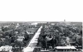
Scarth Street looking south from Hotel Saskatchewan
- CORA-RPL-A-400
- Stuk
- 1927
Part of City of Regina fonds
Looking south on Scarth Street as seen from the Hotel Saskatchewan. Legislative Buildings are visible in background.
376 results with digital objects Show results with digital objects
Scarth Street looking south from Hotel Saskatchewan
Part of City of Regina fonds
Looking south on Scarth Street as seen from the Hotel Saskatchewan. Legislative Buildings are visible in background.
Part of City of Regina fonds
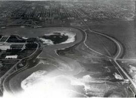
An empty Wascana Lake before the 1931 deepening.
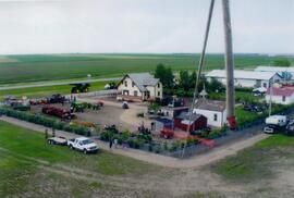
Aerial view of Museum and grounds
Aerial view shows the Tea House, Fire Hall, School, Church, Blacksmith Shop, tractors, and main buildings. Photographed from a SaskTel balloon in 2008.
Flooding of Brouwershaven, island of Schouwen
Part of W.O. Kupsch fonds
Aerial photograph shows the flooded areas in the surroundings of Brouwershaven, island of Schouwen. Can see only the tops of fencelines and roofs of buildings.

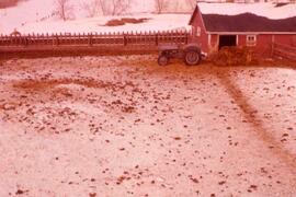
Aerial View of the Melfort Research Farm
Part of Melfort General Photo collection
An aerial view of the Melfort Research Farm in the winter time.
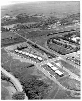
Animal Pens at Melfort Research Station
Part of Melfort General Photo collection
Aerial view of the animal sheds and feeder at the Melfort Research Station.
Aerial view of Moose Jaw, Saskatchewan
Part of MJ General Photograph Collection
Aerial view of new houses in the River Park area of southeast Moose Jaw, Saskatchewan
Aerial view of Moose Jaw, Saskatchewan
Part of MJ General Photograph Collection
Aerial view looking northwest over Canadian Pacific Railway yards with the CPR Roundhouse visible
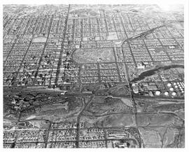
Aerial view of Moose Jaw, Saskatchewan
Part of MJ General Photograph Collection
Aerial view of central Moose Jaw looking north
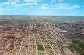
Aerial view of Moose Jaw, Saskatchewan
Part of MJ General Photograph Collection
Aerial view of Moose Jaw, Saskatchewan from the west
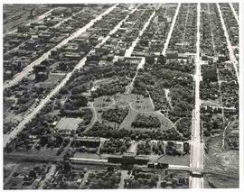
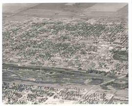
Aerial view of Crescent Park in Moose Jaw, Saskatchewan
Part of MJ General Photograph Collection
Aerial view of Crescent Park and surrounding area in Moose Jaw, Saskatchewan

View from the south of Chemistry (Thorvaldson) Building, Administration Building, Saskatchewan Hall, Qu'Appelle Hall and the Bowl.
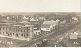
Central Hotel of Esterhazy Sask.
Part of ECM Photograph Collection
An aerial vew of Esterhazy, Saskatchewan with the focal point being The Central Hotel, located at Main St. & Railway Ave. (facing West). This view includes (top left, clockwise): Clements home, Geo. Millham home, church parsonage, Millham granary, Gonczy home, Sellner’s cottage, Cosgrove home built by Dr. Kee, J.Sellner shop, Wilson livery, Mah Jim, C.P.R. pump-house, Shiminoski’s, Krupa’s (burned 1921), Central Hotel’s “Gas house”
Aerial view of northern Baffin Island
Part of W.O. Kupsch fonds
Citation reads: "Aerial view of northern Baffin Island, August 16, 1965."
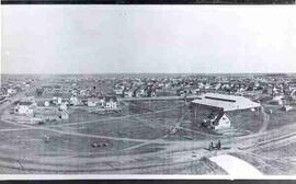
Part of MJ General Photograph Collection
View of Moose Jaw looking southeast from Central Collegiate, showing curling rink and houses