Aerial view of northern Baffin Island
- WOK 20-3
- Item
- 1965
Part of W.O. Kupsch fonds
Citation reads: "Aerial view of northern Baffin Island, August 16, 1965."
376 results with digital objects Show results with digital objects
Aerial view of northern Baffin Island
Part of W.O. Kupsch fonds
Citation reads: "Aerial view of northern Baffin Island, August 16, 1965."
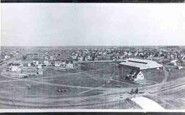
Part of MJ General Photograph Collection
View of Moose Jaw looking southeast from Central Collegiate, showing curling rink and houses
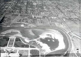
Part of City of Regina fonds
A drained and empty Wascana Lake before it was dredged and deepened in the fall of 1931. As part of a government relief project, 2,100 men (only men who were married and had children were allowed to work on the project) widened and dredged the lake bed and created two islands (Willow and Spruce Island) using only hand tools and horse-drawn wagons.
Aerial view of northern Baffin Island
Part of W.O. Kupsch fonds
Citation reads: "Aerial view of nice cap in distance, fiords in foreground, northern Baffin Island, August 16, 1965."
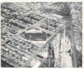
Part of City of Regina fonds
Aerial photograph of Taylor Field (home of the Saskatchewan Roughriders) and surrounding neighbourhood.
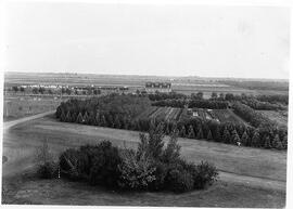
Agricultural Research - Experimental Plots
Elevated view of fields with plants and bushes in foreground; Seed Barn in the distance.
Part of MJ General Photograph Collection
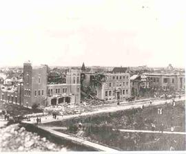
People seen walking around debris in buildings damaged by cyclone in Regina. This image was published in the Moose Jaw Times Herald on May 13, 1955
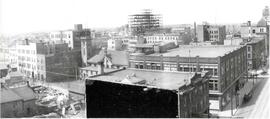
Birds-Eye View of Downtown Regina
Part of City of Regina fonds
Birds-eye view of downtown Regina, looking east down 11th Avenue. McCallum Hill Building is under construction. Old Post Office is visible in far right of frame.
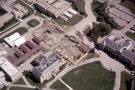
Physics Building - Construction
Aerial view showing construction of the Physics addition, with a partial view of the Bowl and Administration Building.
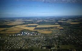
Aerial View of The Rural Municipality of Biggar #347
Part of Biggar Photograph Collection
An aerial view of TP 37 RG 13 in the Rural Municipality of Biggar # 347
Aerial view of northwest quadrant of Lloydminster
Part of LRA Photograph Collection
View of Northwest portion of Lloydminster with the old Catholic Church in foreground
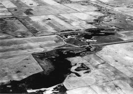
An aerial view of the Blind Creek near Zealandia flooding in the spring. The water flowed west to east and met up with the South Saskatchewan River near Saskatoon.
Indian Head Forest Nursery Station.
Part of Agriculture Collection
Aerial view of the Indian Head Forest Nursery Station in 1952.
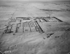
Experimental Farm Regina Substation
Aerial View of The Rural Municipality of Biggar #347
Part of Biggar Photograph Collection
An aerial view of TP 36 RG 17 in the Rural Municipality of Biggar # 347
Aerial View of The Rural Municipality of Biggar #347
Part of Biggar Photograph Collection
An aerial view of TP 36 RG 17 in the Rural Municipality of Biggar # 347