Badlands, South Dakota, Oligocene
- WOK 5-146
- Item
- 1947
Parte de W.O. Kupsch fonds
Badlands, South Dakota, Oligocene.
27 resultados com objetos digitais Mostrar resultados com objetos digitais
Badlands, South Dakota, Oligocene
Parte de W.O. Kupsch fonds
Badlands, South Dakota, Oligocene.
Parte de W.O. Kupsch fonds
Grand Canyon, Arizona. September 1947. W.O.K. and Rob Scholten in photograph.
Glory hole, Ruby Gulch Mine, Little Rock Mountains
Parte de W.O. Kupsch fonds
Glory hole, Ruby Gulch Mine, Little Rock Mountains. Dark yellow green rock under trees to the left is Precambrian amphibolite schist. To the right of this is white veined syenite (Tertiary), to right of this is the Ruby shear zone (gold) in the syenite and farther to the right is syenite with pyrite.
Diagrams related to peneplain, panplain and pediplain
Parte de W.O. Kupsch fonds
Diagrams to suggest the differences in the modes of origin of (A) a peneplain, (B) a panplain, and (C) a pediplain (Thornbury, 1956, p. 182).
Present topography and geologic structure - Dominguez Hills oil field, California
Parte de W.O. Kupsch fonds
Map showing the close correlation between present topography and geologic structure in the Dominguez Hills oil field, California (Thornbury, 1956, p.583)
Buried soil horizon in aeolian sand near Swanson, Sask
Parte de W.O. Kupsch fonds
Buried soil horizon in aeolian sand near Swanson, Sask.
Parte de W.O. Kupsch fonds
Geological map of Canada.
Partly overgrown talus slope near outcrop of Bear Rock limestone
Parte de W.O. Kupsch fonds
Partly overgrown talus slope in front of outcrop of Bear Rock limestone at station WK90.
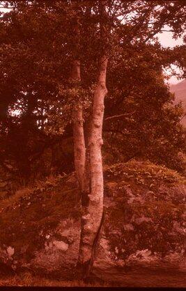
Tree splitting schist boulder.
Parte de W.O. Kupsch fonds
Tree splitting schist boulder. North end of Lock Lomond, Scotland. Photo W.G.E. Caldwell, August 19, 1961.
Salt wort growing on "alkali" salt flat
Parte de W.O. Kupsch fonds
Salt wort ('Salicornia rubra') growing on "alkali" salt flat. Near Cantuar, Saskatchewan Tuesday September 13, 1960.
Lower stratified drift Swift Current Creek section
Parte de W.O. Kupsch fonds
Lower stratified drift Swift Current Creek section along north side of tributary to Swift Current Creek in Sec. 10, T. 19, R. 13, W. 3 meridian. At this place the Lower stratified drift may possible represent a weathered till (cf. Wickenden 1931 C, Sec. C) as it is not stratified, non-sorted, contains some erratics, is highly calcareous but is not a marl (organic, mainly algal, deposit) as Christiansen (1959) reported. Spade is placed on gradational zone from Wymark Till to Lower Stratified drift. Peter David holds hand on sharp contact between Lower stratified drift and AIkins Till. Tuesday September 13, 1960.
Diagram - stages in the development of shoreline emergence
Parte de W.O. Kupsch fonds
Diagram showing the stages in the development of shoreline emergence of the coastal plain type. N nip, SB sub-marine bar, L lagoon, B barrier island, I inlet, TM tidal marsh. Strahler 1960, p. 422.
Diagram showing the formation of a slump in a valley
Parte de W.O. Kupsch fonds
Diagram showing schematically the formation of a slump in a valley within the basalt area. 1. Basalt beds; 2. Dikes; 3. Sedimentary layers; 4. Ice; 5. Rockslide (slump). Iceland.
Development of a broad coastal plain
Parte de W.O. Kupsch fonds
Development of a broad coastal plain. A. Initial stage; plain recently emerged. B. Mature stage; cuestas and lowlands developed. C. Late mature or old age stage; relief very low. Srahler, 1960. p. 450.
Parte de W.O. Kupsch fonds
A simple alluvial fan. Strahler, 1960, p. 359.