- 999-099-010.09
- Pièce
- [1940s-1950s]
Fait partie de Melfort General Photo collection
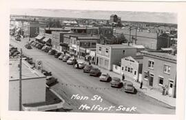
Aerial view of the 200 Block (west side) of Main Street in Melfort, Saskatchewan.
Sans titre
Fait partie de Melfort General Photo collection
Aerial view of the 200 Block (west side) of Main Street in Melfort, Saskatchewan.
Sans titre
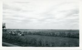
The Dairy Pool, Water Tower and Tourist Camp
Fait partie de Biggar Photograph Collection
An aerial view of the tourist camp, The Dairy Pool, and the water tower in Biggar, Saskatchewan
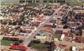
Postcard: "New York Is Big - But This Is Biggar"
Fait partie de Biggar Photograph Collection
Colour postcard showing an aerial view of the town of Biggar, Saskatchewan.
Sans titre
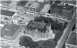
Aerial view of Regina City Hall and Downtown
Fait partie de City of Regina fonds
Aerial view of downtown Regina with Regina City Hall [nicknamed the "Gingerbread Hall"]in centre foreground.
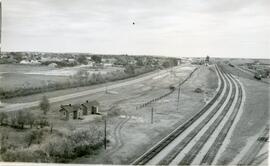
CN Rail Yard and Section House in Biggar, Saskatchewan
Fait partie de Biggar Photograph Collection
An aerial view of the Canadian National Railway (CNR) Section House (foreground) with the CNR rail yard to the right and the town of Biggar, Saskatchewan in the background
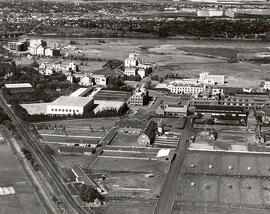
Fait partie de University of Saskatchewan Photograph Collection
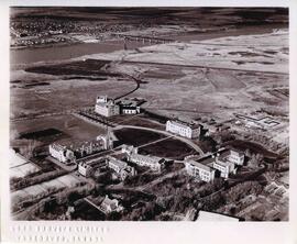
Looking west at Main Barn at centre; Chemistry Building, Administration Building, and other campus buildings also visible. College Drive runs at bottom left.
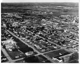
Fait partie de Lloydminster Chamber of Commerce
Aerial view of Lloydminster, Saskatchewan and Alberta, looking northwest.
Sans titre
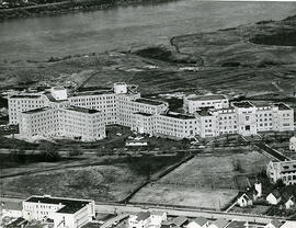
Fait partie de University of Saskatchewan Photograph Collection
Looking north at University Hospital and Medical Building. College Drive in the foreground.
Fait partie de University of Saskatchewan Photograph Collection
Looking north at Qu'Appelle Hall and Saskatchewan Hall in foreground; surrounding campus buildings in background.
Fait partie de University of Saskatchewan Photograph Collection
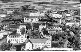
Looking northeast at campus with the Bowl at centre with surrounding buildings; tennis courts at far left.
Fait partie de University of Saskatchewan Photograph Collection
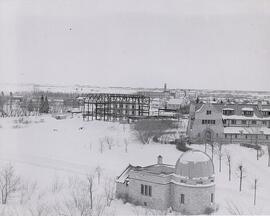
Aerial view looking northeast of the Observatory in winter. Construction of the Memorial Union Building at centre; Emmanuel College at right.
Bio/Historical Note: The Observatory was designed by Gentil J.K. Verbeke and constructed in two phases using local limestone from 1928-1930 for about $23,000. The R. J. Arrand Contracting Co. was contracted to build the Observatory Tower in 1928 for a cost of $6625. The firm completed the tower $353 under budget on 14 April 1929, for $6,272. On 20 June 1929 R. J. Arrand was again awarded a contract by the University, this time to build the small classroom wing of the Observatory for $15,640. Work on the classroom wing was completed on 23 January 1930 for $15,034.50. University funding for the construction of the building was supplemented by private donations. Along with the Field Husbandry Building, the Observatory would be among the last free-standing buildings constructed on campus until after World War II. A plaque with the names of many donors still hangs inside the dome of the observatory. Saskatoon residents will find many of the names highly recognizable even today. A sundial was added to the exterior of the Observatory during the 1940s. It reads:
I am a Shadow
So art thou
The observatory facilities are available for use by both university students and visitors to the campus. The telescopes and other scientific equipment are used by students during the laboratory component of their courses. University personnel regularly offer tours of the observatory to elementary and high school classes, youth groups and other community associations. The Observatory is staffed year-round on Saturday nights so that any visitor may view celestial objects through the telescope.
Fait partie de University of Saskatchewan Photograph Collection
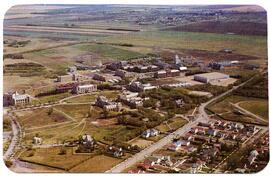
Looking northeast across campus; Varsity View homes on College Drive visible at right.
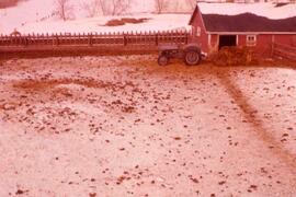
Animal Pens at Melfort Research Station
Fait partie de Melfort General Photo collection
Aerial view of the animal sheds and feeder at the Melfort Research Station.
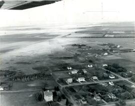
Aerial photo of Indian Head Collegiate and former airport
Fait partie de Town Collection
Photograph taken from an airplane looking northeast over the Indian Head Collegiate (high school) to the former airport - now Indian Head Golf Course.
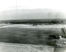
Aerial photo of Indian Head from the north
Fait partie de Town Collection
Photograph taken from an airplane looking south toward Indian Head. The Experimental Farm barn and office building are on the far left of the photograph.