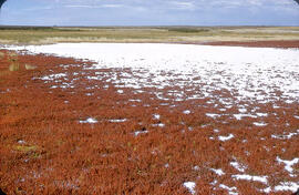
"Alkali" salt flat near Cantuar, Saskatchewan
- WOK 11-139
- Item
- September 13, 1960
Parte de W.O. Kupsch fonds
"Alkali" salt flat at shore of a saline lake near Cantuar, Saskatchewan; note abundance of salt wort (Salicornia rubra).
Sem título
"Alkali" salt flat near Cantuar, Saskatchewan
Parte de W.O. Kupsch fonds
"Alkali" salt flat at shore of a saline lake near Cantuar, Saskatchewan; note abundance of salt wort (Salicornia rubra).
Sem título
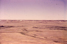
Meandering River in Frenchman Valley near Watson's Bridge
Parte de W.O. Kupsch fonds
Meandering River in Frenchman Valley near Watson's Bridge looking south; one can also see the prominent white band: Whitebud formation (Upper Cretaceous)
Sem título
Alluvial fan from tributary into Qu'Appelle Valley - Katepwa, Saskatchewan
Parte de W.O. Kupsch fonds
Alluvial fan from tributary into Qu'Appelle Valley near Katepwa, Saskatchewan.
Sem título
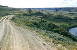
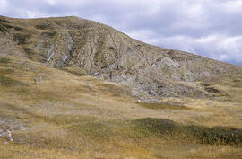
Slumping in valley of Swift Current Creek
Parte de W.O. Kupsch fonds
Slumping in valley of Swift Current Creek in western Saskatchewan
Sem título
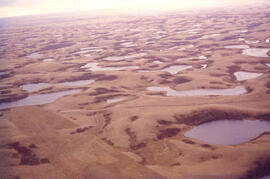
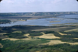
Aerial view of dead ice moraine with knob and kettle topography
Parte de W.O. Kupsch fonds
Aerial view of dead ice moraine with knob and kettle topography; Western part of Moose Mountain, Saskatchewan.
Sem título
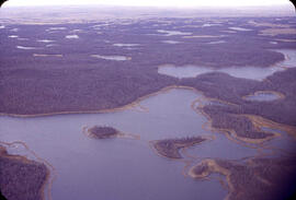
Aerial view of dead ice moraine - effects of lowered water level
Parte de W.O. Kupsch fonds
Aerial view of dead ice moraine showing the effects of lowered water level in ponds; Western part of Moose Mountain, Saskatchewan
Sem título
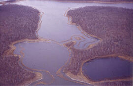
Aerial view of dead ice moraine - effects of lowered water level
Parte de W.O. Kupsch fonds
Aerial view of dead ice moraine showing the effects of lowered water level in ponds; Western part of Moose Mountain, Saskatchewan.
Sem título

Slumping in valley of Swift Current Creek
Parte de W.O. Kupsch fonds
Slumping in valley of Swift Current Creek in western Saskatchewan
Sem título
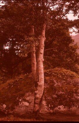
Tree splitting schist boulder.
Parte de W.O. Kupsch fonds
Tree splitting schist boulder. North end of Lock Lomond, Scotland. Photo W.G.E. Caldwell, August 19, 1961.
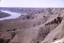
South Saskatchewan River near Prelate Ferry
Parte de W.O. Kupsch fonds
South Saskatchewan River and Pleistocene section near Prelate Ferry, Saskatchewan.
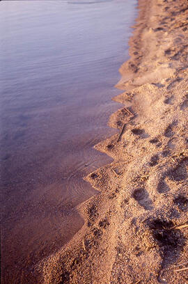
Parte de W.O. Kupsch fonds
Small beach cusps along shore of Dore Lake. May 22, 1976.
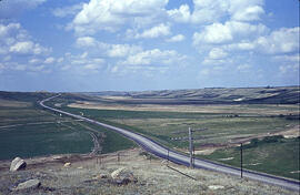
Highway 11 at Blackstrap Coulee
Parte de W.O. Kupsch fonds
Highway 11 crossing Blackstrap Coulee near Dundurn, Saskatchewan. Note lag concentrate of large boulders in foregroundon eroded valley slope; dam in background, reservoir not yet filled. June 1967.
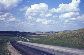
Parte de W.O. Kupsch fonds
Blackstrap Coulee near Dundurn, Saskatchewan. June 1967.
Ice thrust till folding into bedrock
Parte de W.O. Kupsch fonds
General view of till folding into bedrock. In SE corner Sec. 28, T. 10, R. 26, W. 2. Sunday, October 2, 1960.
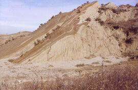
Ice-shove deformation in the Dirt Hills area of Saskatchewan
Parte de W.O. Kupsch fonds
Ice-shove deformation (Tilted Eastend strata) in the Dirt Hills area of Saskatchewan.
Sem título