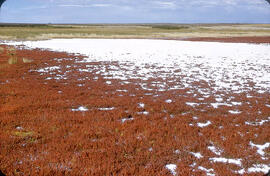
"Alkali" salt flat near Cantuar, Saskatchewan
- WOK 11-139
- Pièce
- September 13, 1960
Fait partie de W.O. Kupsch fonds
"Alkali" salt flat at shore of a saline lake near Cantuar, Saskatchewan; note abundance of salt wort (Salicornia rubra).
Sans titre
20 résultats avec objets numériques Afficher les résultats avec des objets numériques
"Alkali" salt flat near Cantuar, Saskatchewan
Fait partie de W.O. Kupsch fonds
"Alkali" salt flat at shore of a saline lake near Cantuar, Saskatchewan; note abundance of salt wort (Salicornia rubra).
Sans titre

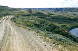
Slumping in valley of Swift Current Creek
Fait partie de W.O. Kupsch fonds
Slumping in valley of Swift Current Creek in western Saskatchewan
Sans titre
Slumping in valley of Swift Current Creek
Fait partie de W.O. Kupsch fonds
Slumping in valley of Swift Current Creek in western Saskatchewan
Sans titre
This fonds contains correspondence and resource material relating to Dr. Kupsch's research, particularly on Frank Davies, Balfour Currie, and the Second International Polar Year; as well as both published and unpublished material from "Gold and Other Stories" and the "Musk-Ox." Additionally, there is considerable reference material relating to uranium mining and nuclear energy, documenting both sides of the ongoing debate over the use of uranium. This fonds also contains an extensive collection of images, documenting 50 years of Dr. Kupsch's field work in northern Saskatchewan and northern Canada, as well as a variety of images relating to the history of geology.
Sans titre
Smelting bitumen from bituminous rocks after Agricola, 1550
Fait partie de W.O. Kupsch fonds
Illustration of smelting bitumen from bituminous rocks after Agricola, 1550. Illustration copied from book.
Fait partie de W.O. Kupsch fonds
Distillation apparatus. Diagram copied from a book.
The wall of watertank at Mohenjo Daro
Fait partie de W.O. Kupsch fonds
Photograph of a watertank at Mohenjo Daro. Shows bituminous layer. Photograph copied from a book.
Cut through the watertank at Mohenjo Daro
Fait partie de W.O. Kupsch fonds
Diagram of a cut through an excavated watertank at Mohenjo Daro. Diagram copied from a book.
Glazed, baked Arabian handgrenade
Fait partie de W.O. Kupsch fonds
Photograph of a glazed and baked Arabian handgrenade filled with inflammable or burning mixtures used in war. Photograph copied from a book.
Damage to agriculture through inundation in the Netherlands, 1945
Fait partie de W.O. Kupsch fonds
Map of areas where there was damage to agriculture through inundation in the Netherlands, 1945. Map copied from a book.
Extent of alluvium deposits in the Netherlands
Fait partie de W.O. Kupsch fonds
Map of the Netherlands showing the extent of alluvium deposits (post Pleistocene or Recent). Map copied from a book.
Dune erosion from gales , North of Bergen aan Zee
Fait partie de W.O. Kupsch fonds
Aerial photograph showing the gaps in dunes caused by violent gales, North of Bergen aan Zee.
Geological cross section of the Alps
Fait partie de W.O. Kupsch fonds
Diagram showing the tectonic section across the Western Alps. Diagram copied from a book.
Outcrop of "Athabasca tar sand" - pit of Abasand quarry
Fait partie de W.O. Kupsch fonds
Outcrop of "Athabasca tar sand" (McMurray formation of Lower Cretaceous age) in a pit of Abasand quarry near McMurray, Alberta.
Air photograph of McMurray, Alberta
Fait partie de W.O. Kupsch fonds
Aerial photograph of McMurray, Alberta.