
Aerial photo of Uranium City, Saskatchewan
- A. General files. Uranium City. Air photos, Uranium City and El Dorado - 1959-1960.
- Item
- June 6, 1960
Parte deR.M. Bone fonds
Aerial view of Uranium City, Saskatchewan.
Sin título
6 resultados con objetos digitales Muestra los resultados con objetos digitales
Aerial photo of Uranium City, Saskatchewan
Parte deR.M. Bone fonds
Aerial view of Uranium City, Saskatchewan.
Sin título
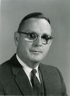
Head and shoulders image of J. Howard Richards, Professor and Head, Department of Geography.
Bio/Historical Note: J. Howard Richards was born 21 May 1916 in Caerphilly, Wales. He enrolled at the University of Wales in 1934 and graduated in 1938 with a B.Sc. in Geography. Richards remained in Wales the following year to teach at a private school and spent the next two years as a Meteorologist in the United Kingdom and Canada. He joined the Royal Canadian Army, serving in Europe from 1942-1946. After his discharge, Richards enrolled at the University of Toronto; in 1947 he received his MA. Richards taught at Utica College of Syracuse University and the University of Manitoba before returning to the University of Toronto, where he earned his PhD in 1956. He briefly joined the staff of the Royal Military College of Canada prior to coming to the University of Saskatchewan in 1960 as Professor and Head of the newly formed Department of Geography. He was to remain in that post until his retirement in 1979. He was named Professor Emeritus in 1983. During his tenure, Richards developed academic programs in Geography and the interdisciplinary programs of Land Use, Environmental Studies and Regional and Urban Development and Planning. He was the editor of the first "Atlas of Saskatchewan" and the author of "Saskatchewan Geography" and "Saskatchewan: A Geographical Appraisal," among other publications.
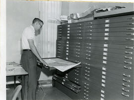
J.C. McConnell, instructor in Geography and Librarian for the Land Use Mapping Project, checks the accuracy of maps made from air photo interpretations.
This collection contains considerable material relating to aviation history, particularly in western and northern Canada, including material on: the Keng Wah Aviation School for Nationalist Chinese pilots; the RCAF; illustrations of the technology of flight; reference material; and microfilms of the Hudson Strait Expedition fonds (1927-1928) and "The Bulletin" (Western Canada Airways, 1929-1937). Additionally, there is material on Tweddell's other research interests, notably aerial mapping and surveying.
Sin título
This fonds consists primarily of material from two studies in which Dr. Bone was associated. The earliest, the "Stony Rapids Project", was conducted while Bone was in the Department of Geography. It started with a small grant from the Canadian Wildlife Service to examine the caribou hunt; ie. the number of people involved and the number of animals taken. The project, however, grew to encompass a wider study of the region and its inhabitants. The second study was undertaken while Bone was with the Institute of Northern Studies (INS). The Northern Saskatchewan Housing Needs Survey was a co-operative effort between the Department of Northern Saskatchewan and the Northern Municipal Council. The primary focus was to investigate the housing needs of the Métis in northern Saskatchewan. The INS was subcontracted to oversee the project, train the surveyors, enter the data, and write the final report. The resulting survey was more than an examination of housing needs. It also contains a great deal of socio-economic data which resulted in one of the most exhaustive studies of its kind. The fact that the surveyors came from the communities studied explains much of the data collection success. Both of these projects offer a unique snapshot of the communities studied. There is also material of a more general nature that deals with northern Saskatchewan, Alberta, Manitoba, and the Yukon and Northwest Territories.
Sin título
This fonds consists largely of Richards' correspondence, lecture materials, personal data, addresses, articles, and research material. His work on the "Atlas of Saskatchewan" is included as is a variety of research material from studies done on an array of topics including land use, mapping, Saskatchewan land inventory, Grasslands National Park, recreational land use, regional planning, land use conflicts, and the NASA course at the Johnson Space Centre.
Sin título
This fonds contains material created or collected by Dr. Williamson during his varied career as an anthropologist, civil servant, legislator, professor, and as a consultant for various provincial, national and international organizations and governments. Although primarily documenting Dr. Williamson's work for and with the Inuit of northern Canada, this fonds includes material relating to all circumpolar countries, other aboriginal groups in Canada, international affairs, and a very broad range of topics as they relate to the north, including art and culture, physical geography, sport, environment, botany, zoology, economics, defence, etc. It includes his personal and professional correspondence, research data, articles and scholarly writing, as well as a substantial collection of reference publications.
Sin título
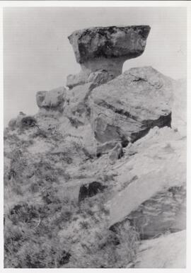
The rock formation that gave Rockglen, Saskatchewan its name.
Parte deMJ General Photograph Collection
Photograph of the local rock formation which gave the town of Rockglen, Saskatchewan its name. It was later removed as it was considered dangerous.
This fonds contains materials primarily related to Moss's work on the soil survey of Saskatchewan, and academic work connected to soil classification and land use.
Sin título
Map of the Netherlands, 16th century
Parte deW.O. Kupsch fonds
Map of the Netherlands during the 16th century. Shows the land area and drainage channels.
A section of Polderland, Holland
Parte deW.O. Kupsch fonds
Map of a section of Polderland, Holland. Map copied from a book.
Dune erosion from gales , North of Bergen aan Zee
Parte deW.O. Kupsch fonds
Aerial photograph showing the gaps in dunes caused by violent gales, North of Bergen aan Zee.
Outcrop of "Athabasca tar sand" - pit of Abasand quarry
Parte deW.O. Kupsch fonds
Outcrop of "Athabasca tar sand" (McMurray formation of Lower Cretaceous age) in a pit of Abasand quarry near McMurray, Alberta.
Air photograph of McMurray, Alberta
Parte deW.O. Kupsch fonds
Aerial photograph of McMurray, Alberta.
Swash marks on Peter Pond Lake
Parte deW.O. Kupsch fonds
Swash marks on Peter Pond Lake (Big Buffalo) Lake beach at Sandy Point, Saskatchewan