Regina (Sask.)

Taxonomy

Code

Scope note(s)

Source note(s)

Display note(s)

Hierarchical terms

Regina (Sask.)

Equivalent terms

Regina (Sask.)

Associated terms

Regina (Sask.)

34 Archival description results for Regina (Sask.)

34 results directly related Exclude narrower terms

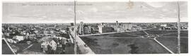
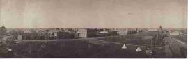
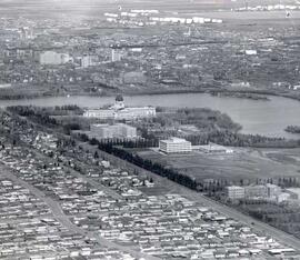
Aerial view of Regina looking northeast

Aerial view looking northeast over the city. The Legislative Buildings, Wascana Lake and Campion College are seen in foreground. From Thornton Avenue to outer city limits (north), Rae Street to east edge of Wascana Park.

Aerial view of Regina, Saskatchewan

The City of Regina as seen from the top of the Metropolitan Methodist Church. Victoria Park is visible in the left of the frame. Little landscaping has been done to the park.

Birds'-eye view of Victoria Park in Regina

Aerial view of Victoria Park in Regina, looking south towards Victoria Avenue. The Baptist Church and the Land Titles Building are visible and the Victoria Park Fountain is still the centre of Victoria Park (replaced by the World War I Cenotaph in 1928]

Hamilton and 11th Avenue

Corner of Hamilton & 11th Avenue, taken from the park in front of the old (gingerbread) city hall. Old post office, Woolworth's and United Cigar are visible.

Lorne Street and Victoria Avenue

Corner of Lorne Street and Victoria Avenue in Regina, looking north; Victoria Park is located on the right, Metropolitan Presbyterian Church and Knox Presbyterian Church are also visible in the frame.

Results 1 to 15 of 34