- A-6002
- Item
- Sept. 1967
Looking west with the Bowl and surrounding buildings at centre of image; several people can be seen in the Bowl.
750 resultados diretamente relacionados Excluir termos específicos
Looking west with the Bowl and surrounding buildings at centre of image; several people can be seen in the Bowl.
Six images taken from straight above. The primary subject is the University of Saskatchewan farmland but also includes the campus grounds, the South Saskatchewan River and Saskatoon residential
Image taken from directly over University of Saskatchewan farmland; campus grounds, the South Saskatchewan River and Saskatoon residential neighbourhoods also visible.
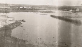
Aerial view of flooding around campus buildings; Field Husbandry barn at right and greenhouses at left.
Aerial view looking northwest of Law Building; Robin Hood Mills elevator in background.
Bio/Historical Note: The Law and Commerce Buildings were designed and constructed as part of a single project between 1965 and 1967. The architect was John Holliday-Scott of the Saskatoon firm Holliday-Scott & Associates.
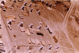
Thorvaldson Building - Construction
Aerial view of foundations of Thorvaldson Addition being laid.
Bio/Historical Note: The Chemistry Building was enlarged with an addition and was renamed in honour of Dr. Thorbergur Thorvaldson, professor and dean of Chemistry from 1919-1959. The Thorvaldson Building opened on 6 June 1966. Architect John B. Parkin’s modern design continued with exterior stone cladding. The near windowless, stone three-storey addition provided classrooms, undergraduate and research laboratories, offices, a library and service facilities.
The Bowl at centre of image with surrounding campus buildings.
The Bowl at centre of image with surrounding campus buildings.
Looking north at campus and University farm fields. South Saskatchewan River, bridges, weir and west side residential districts also visible.
The Bowl at centre surrounded by campus buildings.
View of Saskatoon and campus; Sutherland at centre of image.
University of Saskatchewan College of Education Building
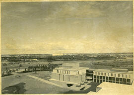
Aerial view of the exterior of the College of Education building and Diefenbaker Centre.
View of Protein, Oil and Starch (POS) Pilot Plant at centre of image, with all of campus in view. Fields, bridges, weir, South Saskatchewan River and east and west side Saskatoon residential districts are also visible.
The Bowl at centre of image with surrounding campus buildings.
Aerial view of northern Baffin Island
Parte de W.O. Kupsch fonds
Citation reads: "Aerial view of nice cap in distance, fiords in foreground, northern Baffin Island, August 16, 1965."