Title and statement of responsibility area
Title proper
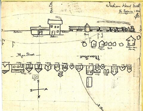
Hand-drawn map/sketch of Indian Head in 1882
General material designation
- Graphic material
Parallel title
Other title information
Title statements of responsibility
Title notes
Level of description
Item
Repository
Reference code
Edition area
Edition statement
Edition statement of responsibility
Class of material specific details area
Statement of scale (cartographic)
Statement of projection (cartographic)
Statement of coordinates (cartographic)
Statement of scale (architectural)
Issuing jurisdiction and denomination (philatelic)
Dates of creation area
Date(s)
Physical description area
Physical description
Hand-drawn sketch/map: b&w; 18 x 24 cm
Publisher's series area
Title proper of publisher's series
Parallel titles of publisher's series
Other title information of publisher's series
Statement of responsibility relating to publisher's series
Numbering within publisher's series
Note on publisher's series
Archival description area
Name of creator
Biographical history
Edwin Jackson Brooks was born in Lennoxville, Quebec, in 1949. He and his twin brother Edward arrived in July, 1882 and chose land just west of Indian Head, only to be told that the land had already been reserved by the Qu'Appelle Valley Company (Bell Farm). He later chose land north of Indian Head (Wide Awake District). He became a prominent citizen and merchant in Indian Head. In 1885, he was selected to serve on the jury for the trial of Louis Riel.
Custodial history
Scope and content
Sketch/map by Edwin J. Brooks of the CPR station and buildings along the railway - all labelled. A path (later Grand Avenue) goes to the northwest and is labelled "To Bell..."
Notes area
Physical condition
Immediate source of acquisition
Arrangement
Language of material
Script of material
Location of originals
PS2
Availability of other formats
Restrictions on access
Terms governing use, reproduction, and publication
Finding aids
Associated materials
Accruals
General note
The sketch was before Indian Head was a town and so the only street, labelled Main Street, is actually North Railway Avenue - possibly the easterly part being present-day Main Street, which currently begins at the corner of Grand Avenue and North Railway Avenue and proceeds northeasterly..
Reverse: "Main Street 1882. Copy of sketch map drawn by E.J. Brooks for his wife on Nov. 16, '82. Vital Statistics: Stores = 3, Hotels = 3, Tents = 8, Bakery = 1,Laundry = 1, Houses = 4, Livery barn = 1. All strung along the newly laid track, opposite the old station and freight shed."
Alternative identifier(s)
Standard number area
Standard number
Access points
Subject access points
Place access points
Name access points
- Brooks, Edwin Jackson (Subject)