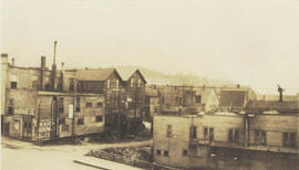
- WOK 19-149
- Item
- 1965
Parte de W.O. Kupsch fonds
Citation reads: "General view of mining camp, Mary River, N.W.T. August 15, 1965."

230 resultados com objetos digitais Mostrar resultados com objetos digitais
Parte de W.O. Kupsch fonds
Citation reads: "General view of mining camp, Mary River, N.W.T. August 15, 1965."
Aerial view of settlement, Inuvik, N.W.T.
Parte de W.O. Kupsch fonds
Citation reads: "Aerial view of settlement, Inuvik, N.W.T. August 22, 1965."
Parte de Institute for Northern Studies fonds
A closeup of a street in Prince Rupert, BC.

"View of Prince Rupert Water Front"
Parte de Institute for Northern Studies fonds
An aerial view of Prince Rupert, BC.

Aerial photo of Uranium City, Saskatchewan
Parte de R.M. Bone fonds
Aerial view of Uranium City, Saskatchewan.
Sem título
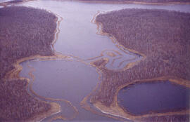
Aerial view of dead ice moraine - effects of lowered water level
Parte de W.O. Kupsch fonds
Aerial view of dead ice moraine showing the effects of lowered water level in ponds; Western part of Moose Mountain, Saskatchewan.
Sem título
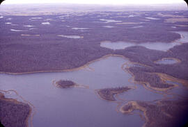
Aerial view of dead ice moraine - effects of lowered water level
Parte de W.O. Kupsch fonds
Aerial view of dead ice moraine showing the effects of lowered water level in ponds; Western part of Moose Mountain, Saskatchewan
Sem título
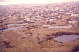
Aerial view of dead ice moraine with knob and kettle topography
Parte de W.O. Kupsch fonds
Aerial view of dead ice moraine with knob and kettle topography; Western part of Moose Mountain, Saskatchewan.
Sem título
Rubber boats dropped by plane in rescue operations
Parte de W.O. Kupsch fonds
Aerial photograph of rubber boats being used to rescue people during flood.
Rescuing people from trees after flood
Parte de W.O. Kupsch fonds
Aerial photograph shows a helicopter rescuing people from trees after flooding. Can also see the damage to the dike in the background.
Water flowing through damaged dikes
Parte de W.O. Kupsch fonds
Aerial photograph of water streaming with great force through two gaps in the dikes.
Aerial view of settlement, Aklavik, N.W.T.
Parte de W.O. Kupsch fonds
Citation reads: "Aerial view of settlement, Aklavik, N.W.T. August 22, 1965."
Dune erosion from gales , North of Bergen aan Zee
Parte de W.O. Kupsch fonds
Aerial photograph showing the gaps in dunes caused by violent gales, North of Bergen aan Zee.
Flooding of Brouwershaven, island of Schouwen
Parte de W.O. Kupsch fonds
Aerial photograph shows the flooded areas in the surroundings of Brouwershaven, island of Schouwen. Can see only the tops of fencelines and roofs of buildings.

View from the south of Chemistry (Thorvaldson) Building, Administration Building, Saskatchewan Hall, Qu'Appelle Hall and the Bowl.