Aerial photograph of domal stream adjustment and annular stream pattern with tonal haloo around topographic high, which is coincident with seismic high. Braddock structure, Sask.
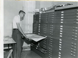
J.C. McConnell, instructor in Geography and Librarian for the Land Use Mapping Project, checks the accuracy of maps made from air photo interpretations.
Horse Creek Valley near McMurray, Alberta. Outcrop of McMurray formation (Lower Cretaceous), commonly called "tar sand" overlain by Clearwater formation (Lower Cretaceous)
Outcrop of "Athabasca tar sand" (McMurray formation of Lower Cretaceous age) along road to Abasand quarry near McMurray, Alberta. Colin McKenzie on slope.
Meandering River in Frenchman Valley near Watson's Bridge looking south; one can also see the prominent white band: Whitebud formation (Upper Cretaceous)