Lodgepole Canyon, Little Rocky Mountains, Montana
- WOK 1-83
- Stuk
- 1953
Part of W.O. Kupsch fonds
Lodgepole Canyon, Little Rocky Mountains, Montana.
6 results with digital objects Show results with digital objects
Lodgepole Canyon, Little Rocky Mountains, Montana
Part of W.O. Kupsch fonds
Lodgepole Canyon, Little Rocky Mountains, Montana.
Lodgepole Canyon, Little Rocky Mountains
Part of W.O. Kupsch fonds
Lodgepole Canyon, Little Rocky Mountains
Missouri River near Wolf Point, Montana
Part of W.O. Kupsch fonds
Missouri River near Wolf Point, Montana. Fort Union (Paleocene) highland in background. Identity of individuals in photograph unknown.
Clastic dike in Flaxville formation
Part of W.O. Kupsch fonds
Clastic dike in Flaxville formation (Miocene-Pliocene), Near Orpheim, Montana. IDentity of individual in photograph unknown.
Aerial view of domal stream adjustment and annular stream pattern
Part of W.O. Kupsch fonds
Aerial photograph of domal stream adjustment and annular stream pattern with tonal haloo around topographic high, which is coincident with seismic high. Braddock structure, Sask.

J.C. McConnell, instructor in Geography and Librarian for the Land Use Mapping Project, checks the accuracy of maps made from air photo interpretations.
Population density shown on world map
Part of W.O. Kupsch fonds
Population density shown on world map.
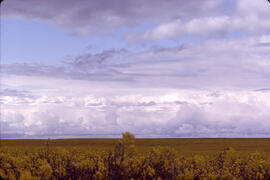
Part of Hans Dommasch fonds
The flat horizon is seen over a field of yellow plants near Emma Lake, Saskatchewan.
Zonder titel
This fonds contains reference material, correspondence, reports, manuscripts, maps and research data relating to Dr. Chakravarti's research, teaching, and administrative career. Included are correspondence relating to, and manuscripts of, many of Chakravarti's published articles. Dr. Chakravarti has published widely in the following fields: synoptic climatology; precipitation patterns, drought and dust storms on the Canadian prairies; and agricultural and foods problems in India. The administrative series contains material relating to the restructuring of the Geography graduate program in the 1980s and to the appointments made in the department. The teaching series includes lecture notes, exams and assignments, and student evaluations.
Zonder titel
Map of the Netherlands during Roman times
Part of W.O. Kupsch fonds
Map of the Netherlands during Roman times showing land area and river channels.
Part of W.O. Kupsch fonds
Horse Creek Valley near McMurray, Alberta. Outcrop of McMurray formation (Lower Cretaceous), commonly called "tar sand" overlain by Clearwater formation (Lower Cretaceous)
Outcrop of "Athabasca tar sand" along road
Part of W.O. Kupsch fonds
Outcrop of "Athabasca tar sand" (McMurray formation of Lower Cretaceous age) along road to Abasand quarry near McMurray, Alberta. Colin McKenzie on slope.
Part of W.O. Kupsch fonds
Photograph taken on a windy day on Peter Pond Lake (Big Buffalo Lake), Saskatchewan
Lodgepole Canyon, Little Rocky Mountains
Part of W.O. Kupsch fonds
Lodgepole Canyon, Little Rocky Mountains, Montana. Identity of individual in photograph unknown.
Basic intrusive related to Bearpaw Mountains, Montana
Part of W.O. Kupsch fonds
Basic intrusive related to Bearpaw Mountains. Three Buttes along highway Harlem-Hays, Montana