- INS-810
- Stuk
- Fall, 1970
The University of Saskatchewan campus in Saskatoon, SK.
27 results with digital objects Show results with digital objects
The University of Saskatchewan campus in Saskatoon, SK.
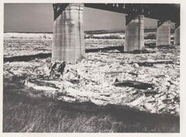
Ice jamming against a [Saskatchewan Landing] Bridge pier in the South Saskatchewan River during spring breakup. Saskatoon, SK. (A magazine article accompanies the photograph)
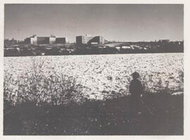
The break up of the ice on the South Saskatchewan River. On the west bank looking east toward the ski jump on the University of Saskatchewan grounds. Saskatoon, SK.
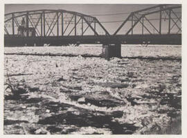
Ice jamming against the [C.P.R.(Canadian Pacific Railway)] Bridge piers during spring breakup in the South Saskatchewan River. Saskatoon, SK.
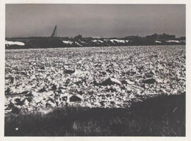
The ice on the South Saskatchewan River during spring breakup. On the west bank, looking east toward the University of Saskatchewan, Ellis Hall, and the University Hospital. Saskatoon, SK.
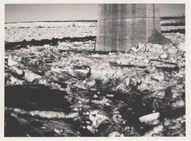
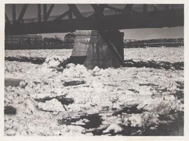
Ice jammed against the pier of the Traffic Bridge (off 19th St.); with the Bessborough Hotel in the background. Note the candled ice, dust cover, and flotsam. Spring breakup, Saskatoon, SK.
An ice jam against the C.N.R. (Canadian National Railway) Bridge pier during spring breakup. The South Saskatchewan River, Saskatoon, SK.
Looking north into two kettle holes in end moraine ridge
Part of W.O. Kupsch fonds
Station WK70, looking north into two kettle holes in end moraine ridge. Thursday, August 6, 1959.
End moraine south of Horton Lake
Part of W.O. Kupsch fonds
End moraine south of Horton Lake as seen from the air (station WK70). Looking north. The ice moved from east to west. Note steeper proximal (east) side of end moraine and gentler distal (west) side grading into outwashplain. Thursday, August 6, 1959.
Fluting, grooved and drumlinized bedrock west of Bloody River
Part of W.O. Kupsch fonds
Fluting, grooved and drumlinized bedrock west of Bloody River. Aerial view looking west in the direction of the ice movement. Thursday 6 August, 1959.
Fluting, grooved and drumlinized bedrock west of Bloody River
Part of W.O. Kupsch fonds
Fluting, grooved and drumlinized bedrock west of Bloody River. Aerial view looking west in the direction of the ice movement. Thursday 6 August, 1959.
Glacier distorted silt underlying till
Part of W.O. Kupsch fonds
Glacier distorted silt underlying till at station WK61. This exposure is oriented northeast-southwest with the northeast at the right hand side of the picture. Distortions indicate local ice movement from the northeast (right).
Patterned ground of stone polygons
Part of W.O. Kupsch fonds
Patterned ground of stone polygons, mainly unsorted to poorly sorted. Station WK54. Tuesday, July 7, 1959.
Eroded moraine with lag concentrate
Part of W.O. Kupsch fonds
Eroded moraine with lag concentrate. Upper terrace of South Saskatchewan River north of Sutherland.
Rolling hummocky disintegration moraine
Part of W.O. Kupsch fonds
Rolling hummocky disintegration moraine near St. Denis, east of Saskatoon.